Part 2 · Peoples
Fremont Culture
The most visible ancient culture in Emery County: Fremont pit houses, pottery, irrigation, and the spectacular rock art panels of the San Rafael Swell.
Ch09 — Fremont Culture
The Fremont are the most visible ancient culture in Emery County — not because they left the largest ruins or the deepest refuse middens, but because they left their images on the rock. Trapezoidal figures with horned headdresses and elaborate necklaces stare out from sandstone panels along Rochester Creek, Temple Mountain Wash, and a dozen other drainages in the San Rafael Swell. These petroglyphs and pictographs, along with pit house foundations, scattered potsherds, stone tools, and the faint traces of irrigation ditches, are the material record of a people who occupied this landscape for more than a thousand years — and then, within the span of a few generations around AD 1300, stopped being archaeologically visible. Understanding who the Fremont were, how they lived, and why their distinctive cultural signature dissolved requires looking closely at the specific places they chose and the specific adaptations they made. In Emery County, those adaptations were shaped by the same environmental gradient that defines every chapter of this book: the vertical distance between the Green River bottoms and the Wasatch Plateau, and the horizontal distance between the watered canyon floors and the exposed desert between them.
9.1 Chronology & Periodization (AD 1–1300)
The Fremont culture takes its name from the Fremont River in south-central Utah, where Noel Morss first described the tradition in 1931 after excavating sites that clearly differed from the Ancestral Puebloan (Anasazi) materials found to the south and east. The culture is now understood to encompass a broad range of regional variants across Utah and portions of Nevada, Colorado, Idaho, and Wyoming. In Emery County, the relevant variant is the San Rafael Fremont, centered on the San Rafael Swell and the drainages that feed the Green and Colorado Rivers.
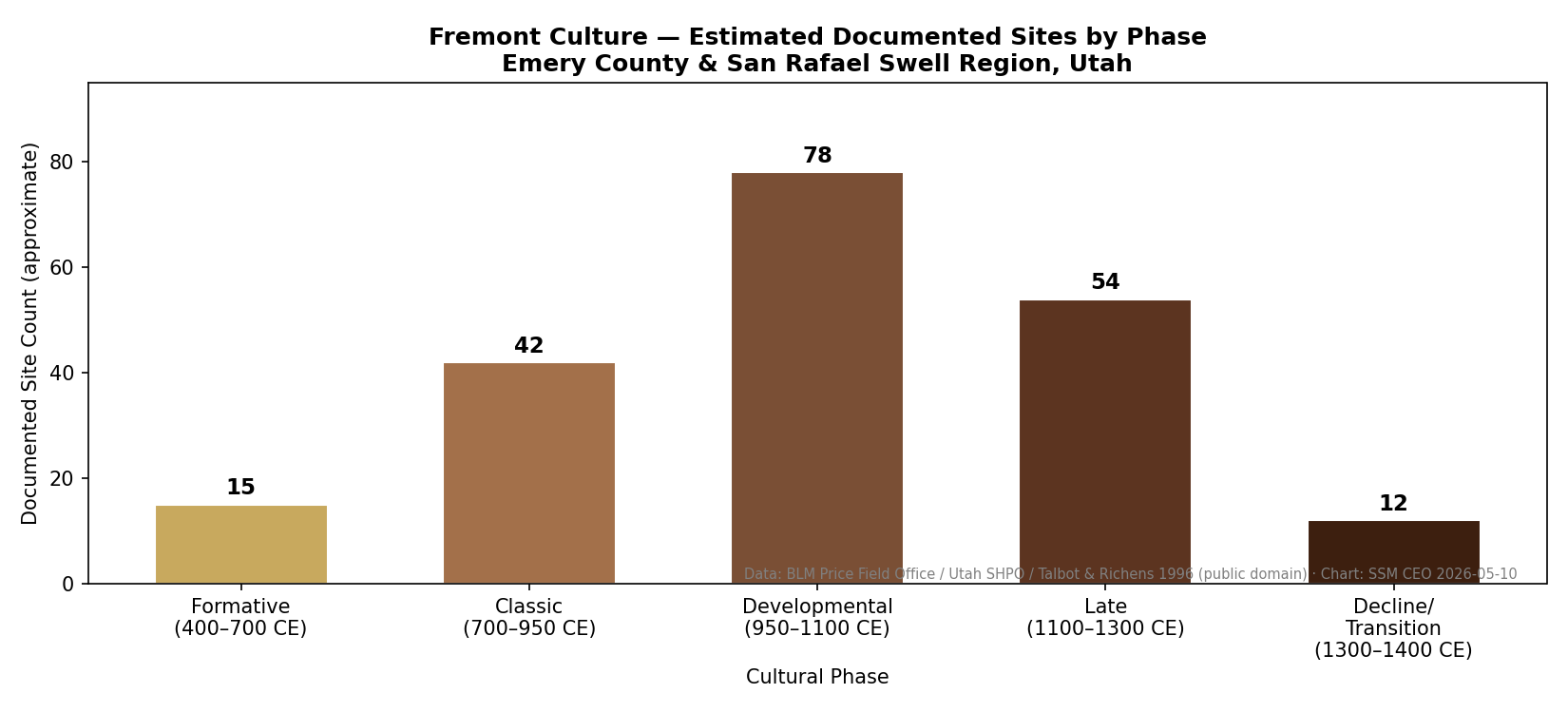
Chronological boundaries are necessarily approximate. The earliest Fremont traits — corn agriculture, distinctive ceramics, and pit house architecture — appear in the archaeological record around AD 400–500 in some regions, though scattered evidence of incipient horticulture and settled village life extends back to the first centuries AD. The San Rafael variant is generally dated to approximately AD 700–1300, with peak population and cultural elaboration occurring between AD 900 and 1200.
The terminal date is more sharply defined. By approximately AD 1250–1300, Fremont cultural markers — the distinctive pottery, the rock art conventions, the architectural patterns — disappear from the archaeological record across the entire region. This timing coincides with the prolonged drought of the late thirteenth century, the same climatic event implicated in the abandonment of Mesa Verde and other Ancestral Puebloan centers to the southeast. But as we will see in Section 9.12, “disappearance” is the wrong word. The people did not vanish. The cultural complex — the particular constellation of practices that archaeologists call “Fremont” — dissolved, and the people who had practiced it reorganized their lives in ways that no longer left the same material signature.
It is worth noting that the Fremont are not the oldest human presence in this landscape. The Barrier Canyon Style rock art found at Buckhorn Wash, the Head of Sinbad, and other San Rafael Swell sites predates the Fremont by thousands of years, with some panels tentatively dated to 6000 BC or earlier. The Fremont arrived in a landscape already rich with human history — and at several rock art sites, they added their own images directly on top of or adjacent to the older Barrier Canyon figures, creating palimpsests of cultural expression spanning millennia.
9.2 Ceramic Traditions & Basketry Techniques
Pottery is one of the primary diagnostic markers of the Fremont, and it is one of the clearest ways to distinguish Fremont sites from Ancestral Puebloan ones in regions where the two traditions overlapped. Fremont ceramics are predominantly plain graywares — utilitarian cooking and storage vessels built by the coil-and-scrape method, with surfaces left undecorated or only minimally smoothed. The dominant types in Emery County are Emery Gray and Snake Valley Gray, both tempered with locally available materials: sand, calcite, or crusite fragments depending on the geology of the immediate area.
Decorative pottery is rare in the Fremont tradition compared to the elaborate painted wares of the Ancestral Puebloans. When decoration appears, it typically takes the form of incised lines, fingernail impressions, or small appliqué elements — clay pellets or raised ridges pressed onto the vessel surface before firing. The relative plainness of Fremont ceramics is not a sign of lesser skill; it reflects different cultural priorities. The Fremont invested their artistic energy elsewhere — most conspicuously, in rock art.
Basketry provides another key diagnostic. The Fremont used a distinctive one-rod-and-bundle construction technique, in which a single flexible rod is wrapped with plant fibers to form the coil foundation. This differs from the two-rod-and-bundle technique standard among the Ancestral Puebloans. Basketry fragments preserved in dry cave and rockshelter sites across the region consistently show this pattern. Alongside basketry, Fremont artisans produced moccasins from the hock skin of deer and mountain sheep — a uniquely Fremont artifact type that has been recovered from cave deposits in the Uinta Basin and elsewhere, and whose presence at a site is considered a strong Fremont diagnostic.
Fremont Ceramic Types in the San Rafael Region
| Type | Temper material | Surface treatment | Primary use |
|---|---|---|---|
| Emery Gray | Sand, calcite | Plain or lightly smoothed | Cooking and storage |
| Snake Valley Gray | Crushed quartzite | Plain, occasionally incised | Cooking and storage |
| Uinta Gray | Sand or grit | Corrugated or neck-banded | Cooking |
| Turner Gray | Calcite | Neck-banded, plain body | Storage and transport |
All four types are utilitarian graywares built by the coil-and-scrape method. The relative plainness of Fremont ceramics compared to Ancestral Puebloan painted wares reflects different cultural priorities: the Fremont invested their artistic energy in rock art.
9.3 Agriculture & Domesticated Crops
The Fremont practiced maize agriculture, and this single fact set them apart from the purely foraging peoples who had occupied the same landscapes during the preceding Archaic period. But Fremont agriculture was a supplement, not a foundation. Unlike the Ancestral Puebloans, who built their entire settlement system around reliable agricultural production, the Fremont maintained a flexible subsistence strategy in which corn, beans, and squash were cultivated when and where conditions allowed, while hunting and wild plant gathering continued to provide the bulk of the diet in most times and places.
In Emery County, this flexibility was a practical necessity. The growing season at Castle Dale’s elevation (~5,770 feet) is roughly 110 to 130 frost-free days — adequate for short-season maize varieties but marginal enough that a single late frost or early freeze could destroy a season’s crop. At higher elevations on the Wasatch Plateau, agriculture was impractical entirely. The Fremont corn cobs recovered from San Rafael Swell sites tend to be small-eared varieties, adapted to short growing seasons and limited water. These were not the large, productive varieties cultivated on the well-watered terraces of the Rio Grande or the irrigated fields of the Hohokam. They were a hedge — a caloric supplement that reduced but did not eliminate dependence on wild resources.
The agricultural plots themselves have largely been obliterated by subsequent erosion and land use, but their former presence is inferred from the concentration of habitation sites along perennial and seasonal drainages — Muddy Creek, Ferron Creek, Cottonwood Creek, and the San Rafael River — where floodplain soils and accessible water would have made small-scale farming viable.
9.4 Pit House & Village Architecture
Fremont residential architecture in Emery County followed the pit house pattern common across the broader culture area. A pit house is a semi-subterranean structure: a shallow pit excavated into the ground, typically one to two feet deep and eight to fifteen feet in diameter, with a framework of wooden posts supporting a roof of poles, brush, and earth. The resulting structure was partially insulated by the surrounding soil — cool in summer, relatively warm in winter — and required less construction material than a fully above-ground building.
Village size was small. Most Fremont habitation sites in the San Rafael region consist of two to twelve pit houses clustered near a water source, with associated storage features — often small adobe-walled granaries built on elevated ledges or in rockshelters above the living area. The granaries were placed high to protect stored crops from rodents, moisture, and flooding. This vertical separation of living space (on the valley floor) and storage space (in cliff alcoves) is a distinctive Fremont pattern that differs from the Ancestral Puebloan practice of integrating storage rooms directly into the residential pueblo.
No Emery County Fremont site approaches the scale or architectural complexity of the multi-story masonry pueblos built by the Ancestral Puebloans at Chaco Canyon, Mesa Verde, or even the smaller Coombs Site near Boulder, Utah. Fremont architecture was practical, expedient, and scaled to the small communities that built it. The modesty of the architecture should not be mistaken for cultural poverty; it reflects a settlement strategy adapted to mobility and environmental variability. When conditions changed — when a drought reduced crop yields or when game moved to different seasonal ranges — a pit house community could relocate more easily than a masonry pueblo.
Build a Fremont Pit-House Model
Using natural materials, build a scale model of a Fremont semi-subterranean pit house. Step 1: Press a shallow oval depression about 1 inch deep into a bed of damp clay or a tray of damp soil — this is the pit. Step 2: Stand six to eight small sticks (4–6 inches) upright around the rim as wall posts, spacing them evenly. Step 3: Lean longer sticks from the rim posts inward to a central point, creating a dome-shaped roof framework. Step 4: Weave dry grass or leaf strips through the framework, then press a thin layer of damp clay over the roof to simulate the earth-and-brush covering. Allow to dry. Once complete, discuss: how does soil surrounding the pit walls insulate the interior compared to above-ground walls? How would a family of four or five people use this single room for sleeping, cooking, and storing food? What would you change to make it work for Emery County winters?
What you'll need:
Damp clay or a tray of moist soil, Small sticks or pencils (4–8 inches), Dry grass, pine needles, or strips of bark, Optional: small stones for a central fire pit
9.5 Rock Art Styles: Fremont vs. Barrier Canyon
Rock art is the cultural achievement for which the San Rafael Swell is best known, and Emery County contains one of the highest concentrations of prehistoric rock art in North America. Two distinct traditions are represented: the older Barrier Canyon Style and the younger Fremont tradition. Understanding the difference between them is essential to reading the landscape.
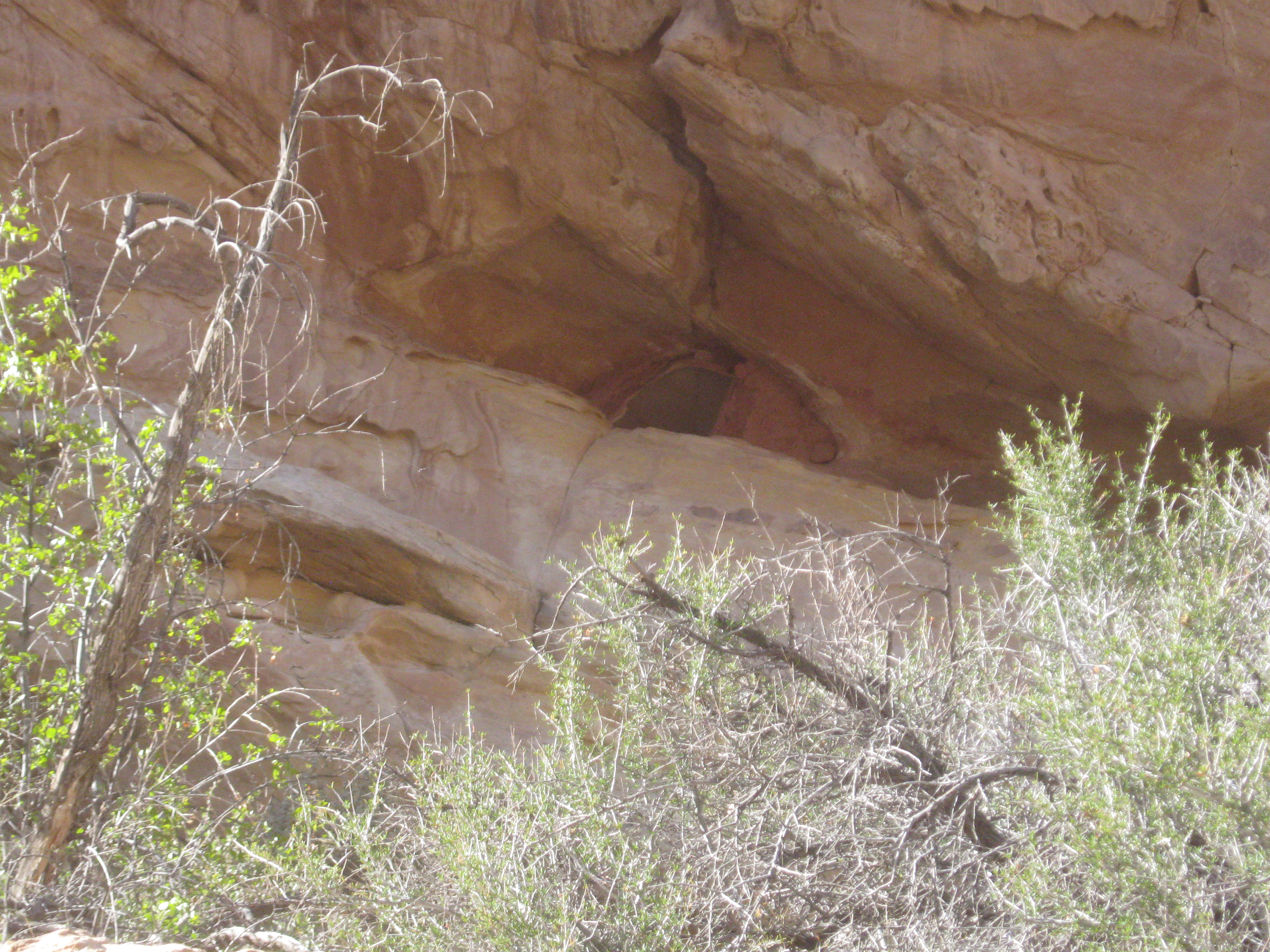
Barrier Canyon Style rock art is among the most visually striking prehistoric art in the Western Hemisphere. The figures are typically large — often life-sized or larger — elongated, and ghost-like, with tapering or absent limbs, hollow eyes, and elaborate body decoration rendered in dark red pigment (pictographs, or painted images). The figures frequently appear in groups, arranged in rows or clusters on smooth sandstone surfaces. The type site is the Great Gallery in Horseshoe Canyon (Canyonlands National Park), but some of the finest Barrier Canyon panels are in Emery County: the Buckhorn Wash Pictograph Panel, accessible by road along the Buckhorn Wash Scenic Byway, is one of the most significant and best-preserved Barrier Canyon Style sites in the world. The Black Dragon Pictograph Panel at the Head of Sinbad, Temple Mountain Wash panels, and numerous smaller sites throughout the Swell add to the concentration.
Barrier Canyon Style dates are debated, but most researchers place the tradition between roughly 6000 BC and AD 500, with some panels possibly extending to AD 1100. The cultural affiliation of the artists is unknown — they predate the Fremont by thousands of years and left no pottery, no architecture, and no other material culture that can be definitively linked to the paintings.
Fremont rock art, by contrast, is primarily executed as petroglyphs — images pecked or incised into the dark desert varnish that coats sandstone surfaces, revealing the lighter rock beneath. Classic Fremont figures are trapezoidal-bodied anthropomorphs: broad-shouldered, narrow-waisted human forms with elaborate headdresses, necklaces, earrings, and shield-like chest decorations. The figures are typically smaller than Barrier Canyon images and are rendered with more anatomical detail — fingers, toes, facial features, and clothing elements are often depicted.
The Rochester Creek Rock Art Panel, located along a tributary of the San Rafael River, contains one of the largest and best-preserved collections of Fremont petroglyphs in Utah. The panel stretches along a cliff face and includes dozens of individual figures, many displaying the classic trapezoidal body form with headdresses and ornaments. Temple Mountain Wash and sites along Muddy Creek contain additional significant Fremont panels.
At several locations in the Swell, Fremont petroglyphs are superimposed on older Barrier Canyon pictographs — the younger images pecked directly over or beside the older painted figures. These palimpsest panels are powerful evidence of temporal sequence and suggest that the Fremont recognized and engaged with the art of their predecessors, whether in homage, appropriation, or simply because the same smooth rock surfaces that attracted Barrier Canyon painters also attracted Fremont artists.

9.6 Lithic Tool Production & Trade Networks
Stone tools are the most ubiquitous Fremont artifacts in Emery County — more common than pottery, more widespread than structural remains, and found on the surface at virtually every site where Fremont people camped, hunted, or worked. The Fremont lithic toolkit included projectile points (arrowheads and dart points), scrapers for processing hides, knives, drills, and grinding stones (manos and metates) for processing both cultivated corn and wild seeds.
Projectile point styles help establish chronology and cultural affiliation. The Fremont commonly used Rose Spring and Eastgate point types — small, corner-notched or side-notched arrow points that replaced the larger Archaic-era dart points as the bow and arrow technology spread across the Great Basin during the first millennium AD. These point types are found throughout the San Rafael Swell and along the drainages feeding the Green River.
The raw materials for stone tools tell a story of trade and interaction. The San Rafael Swell itself provided abundant chert and chalcedony — fine-grained siliceous stones well suited to flaking — and these local materials dominate most Fremont lithic assemblages in the county. But obsidian artifacts, though less common, appear at Fremont sites across the region, and sourcing analysis (matching the chemical composition of obsidian artifacts to known geological sources) demonstrates connections to quarries in central and eastern Nevada, some 200 to 300 miles to the west. These long-distance obsidian connections indicate that the Fremont, despite their small village size and relatively simple architecture, were participants in exchange networks that spanned the Great Basin.
9.7 Irrigation Canals & Water Management
Agriculture in Emery County’s arid environment required some form of water management, and the Fremont responded with small-scale irrigation features that, while modest compared to the elaborate canal systems of the Hohokam in southern Arizona, represent a meaningful adaptation to arid-land farming.
Evidence of Fremont irrigation comes primarily from the discovery of shallow ditches and berms associated with habitation sites along perennial and seasonal drainages. These features diverted seasonal floodwaters or perennial stream flow onto adjacent floodplain surfaces where crops could be grown. The scale was small — single ditches serving individual fields rather than engineered canal systems serving entire communities — and the construction was expedient, using earth berms and natural topography rather than stone-lined channels.
The intermittent drainages of Emery County — Muddy Creek, Ferron Creek, Cottonwood Creek, and the San Rafael River — provided the water. Spring snowmelt from the Wasatch Plateau filled these streams from April through June, and monsoon rains supplemented the flow in July and August. The timing was favorable for maize agriculture: planting could coincide with spring flows, and the monsoon provided supplemental moisture during the critical tasseling and grain-fill stages of growth. In dry years, however, the streams ran low or dry entirely, and crops failed. The Fremont response to this uncertainty was not to build bigger canals but to maintain the hunting and gathering skills that ensured survival when agriculture came up short.
9.8 Diet & Subsistence
The Fremont diet was a blend of cultivated crops and wild resources, and the proportions varied by location, season, and year. Coprolite analysis — the study of preserved fecal matter from dry cave deposits — provides the most direct evidence of what the Fremont actually ate, as opposed to what they might have eaten based on the availability of resources. These analyses, conducted at Fremont sites across the broader culture area, consistently reveal a mixed diet: corn kernels and cob fragments alongside wild grass seeds, pinyon nut shell fragments, prickly pear cactus seeds, and small animal bones.
In Emery County, the wild plant resources available to the Fremont would have included pinyon nuts from the extensive pinyon-juniper woodlands covering the mid-elevation slopes, Indian rice grass seeds from the sandy desert floor, amaranth and goosefoot (chenopodium) growing in disturbed soils near habitation sites, and prickly pear cactus fruits and pads available in summer and fall. The diversity of these resources, distributed across a wide range of elevations and seasons, made a purely agricultural life unnecessary and a purely mobile hunting-and-gathering life equally unattractive. The Fremont solution was to do both — a strategy that archaeologists sometimes call “residential flexibility” or “mixed economy.”
Hunting contributed animal protein. Mule deer and bighorn sheep were the primary large game, supplemented by rabbits, cottontails, and smaller rodents. Communal rabbit drives using long fiber nets are documented at some Fremont sites outside Emery County, and the technique may have been used locally as well. Rabbit drives were social events as much as subsistence activities — they required the cooperation of an entire community and likely served to reinforce social bonds among dispersed family groups.
9.9 Social Organization & Community Interaction
Fremont communities in Emery County were small. Villages of two to twelve pit houses, occupied by perhaps ten to sixty people, were the basic social unit. This scale suggests organization at the household or extended-family level — a band society in anthropological terms — without the more complex clan, moiety, or village-level institutions inferred for contemporaneous Ancestral Puebloan communities at Chaco Canyon or Mesa Verde.
The small size of Fremont communities does not mean they were isolated. Regional interaction is evidenced by the consistency of ceramic styles, rock art conventions, and architectural patterns across the San Rafael variant area. Potters in different drainages used the same construction techniques and temper types; rock art panels along different tributaries share the same iconographic vocabulary of trapezoidal anthropomorphs and elaborate headdresses. This consistency implies regular communication, intermarriage, and shared cultural norms among communities that were individually small but collectively constituted a regional population.
The obsidian trade networks described in Section 9.6 further demonstrate that Fremont communities were embedded in larger systems of exchange and interaction. Whether obsidian arrived through direct procurement by traveling Fremont parties, through down-the-line trade between neighboring groups, or through specialized trading intermediaries is unknown. But the material moved, and its movement connected the San Rafael Swell to the broader Great Basin world.
9.10 Ritual & Ceremonial Practices
The most distinctive Fremont ritual artifacts are unfired clay figurines — small, hand-modeled anthropomorphic figures, typically three to six inches tall, with applied facial features, hairstyles, necklaces, and body decorations. These figurines are found at Fremont sites across Utah, and their function has been debated for decades. Proposed interpretations include ritual or spiritual objects, effigies used in hunting or fertility ceremonies, children’s toys, teaching aids, and gaming pieces. The care with which many figurines were crafted — detailed facial features, elaborate hairstyles that mirror those depicted in rock art — suggests something more than casual manufacture, but the specific meaning remains beyond recovery from the archaeological record alone.
Rock art panels almost certainly served ritual or ceremonial functions. The concentration of elaborate panels at specific locations — Rochester Creek, Buckhorn Wash, Temple Mountain — suggests that these were places of cultural significance, visited repeatedly over generations. Whether the rock art depicts spiritual beings, records of visions or ceremonies, clan or lineage markers, or narrative accounts of historical events (or some combination of these) is debated, and different panels may have served different purposes.
No kivas or other formalized ceremonial structures comparable to those found at Ancestral Puebloan sites have been identified at Fremont sites in Emery County. This does not mean the Fremont lacked organized ritual life — it means their ceremonial practices did not require specialized architecture. Rock art sites themselves may have served as the ceremonial spaces that kivas provided for the Ancestral Puebloans: places set apart from daily life where spiritual work was done.
The eleven Pilling Figurines — unfired clay human figures discovered near Huntington Canyon in 1950 — are among the finest Fremont ritual objects ever recovered. They were stolen from the USU Eastern Prehistoric Museum in Price in 1994 and vanished for seventeen years before being anonymously returned in 2011. No one was ever charged. They are now on display at the College of Eastern Utah Prehistoric Museum in Price, where visitors can see exactly the kind of detailed hairstyles and neck ornaments depicted in the rock art panels of the San Rafael Swell.
— USU Eastern Prehistoric Museum; College of Eastern Utah Prehistoric Museum, Price, Utah
9.11 Site Distribution & Landscape Use
The distribution of Fremont sites across Emery County reflects the environmental logic of the landscape. Habitation sites — pit house villages with associated storage features and refuse deposits — cluster along watercourses: Muddy Creek, the San Rafael River, Ferron Creek, Cottonwood Creek, and the side canyons feeding the Green River. These locations provided the water, arable soil, and riparian resources necessary for sedentary or semi-sedentary life.
Rock art sites concentrate in the San Rafael Swell, particularly along Buckhorn Wash, Rochester Creek, the Head of Sinbad, and Temple Mountain Wash. The Swell’s exposed Navajo and Wingate sandstone provided smooth, varnished surfaces ideal for petroglyph production, and the canyons offered sheltered locations where painted pictographs could survive. The concentration of rock art in the Swell does not necessarily mean more people lived there; it may reflect the Swell’s role as a ceremonial or gathering landscape — a place visited seasonally for ritual, trade, or communal hunting rather than year-round residence.
Seasonal movement — transhumance — likely connected the lowland habitation sites to the upland resources of the Wasatch Plateau and the Book Cliffs. In summer, Fremont groups would have moved to higher elevations to hunt deer and mountain sheep, gather berries and root crops, and escape the desert heat. In fall, pinyon nut harvesting in the mid-elevation woodlands would have drawn people to the pinyon-juniper belt. In winter, the lower elevations along the river bottoms offered the mildest temperatures and the best access to stored food supplies. This seasonal round — lowlands in winter, uplands in summer, pinyon belt in fall — is the same pattern followed by historic Ute bands and, in modified form, by Anglo ranchers who still move cattle between winter range and summer pasture on the Plateau.
Cave and rockshelter sites in the canyon walls served as seasonal camps, storage locations, and sheltered work areas. Many of the best-preserved Fremont artifacts — moccasins, basketry, figurines, wooden implements — come from dry rockshelter deposits where the absence of moisture prevented organic materials from decaying. These sites function as time capsules, preserving a record of daily life that the open-air pit house villages, exposed to centuries of erosion, have largely lost.
9.12 Legacy & Modern Tribal Collaborations
The Fremont did not disappear. The archaeological record shows that around AD 1250–1300, the constellation of traits that define “Fremont” — the distinctive pottery, the rock art conventions, the pit house villages, the mixed farming-and-foraging economy — ceased to be produced. But the people who had been Fremont continued to live. They dispersed, reorganized, and adopted new subsistence strategies and cultural practices that left different (and often less visible) archaeological signatures.
The relationship between the Fremont and modern tribal nations is complex, politically significant, and the subject of ongoing research. Multiple tribes — the Ute, Paiute, Goshute, Shoshone, and possibly the Hopi and other Puebloan peoples — may have ancestral connections to Fremont populations. The Numic-speaking peoples (ancestors of the modern Ute, Paiute, Goshute, and Shoshone) who appear in the archaeological record of the eastern Great Basin in the centuries following the Fremont period may include descendants of Fremont communities who adopted new languages and lifeways as climatic and social conditions changed. This is not settled science — the “Numic expansion” and its relationship to the Fremont dissolution remain among the most debated questions in Great Basin archaeology.
What is settled is the legal and ethical framework governing Fremont sites today. The Native American Graves Protection and Repatriation Act (NAGPRA) of 1990 requires consultation with culturally affiliated tribes when human remains or sacred objects are discovered or disturbed. Section 106 of the National Historic Preservation Act requires federal agencies to consider the effects of their undertakings on historic properties, including archaeological sites. In Emery County, where the Bureau of Land Management administers the majority of the land containing Fremont and Barrier Canyon sites, these consultation requirements are a routine part of any development, road-building, or land-management action in the San Rafael Swell.
Site stewardship is a shared responsibility. The BLM Price Field Office manages most rock art sites in the Swell, and several of the most significant panels — Buckhorn Wash, Rochester Creek — have been listed on the National Register of Historic Places. The Civilian Conservation Corps built protective barriers at some sites in the 1930s, and modern volunteer site steward programs continue the work of monitoring, documenting, and protecting panels from vandalism and natural deterioration. The Utah Rock Art Research Association (URARA) conducts annual documentation projects, and tribal representatives participate in site management planning for the most sensitive locations.
The Fremont legacy in Emery County is not a closed chapter. New sites are discovered every year, often by hikers and ranchers who notice a scatter of potsherds or a previously unrecorded petroglyph panel. Each new discovery adds to the record and occasionally revises the story. The rock art panels that the Fremont carved into the sandstone a thousand years ago still stare out from the canyon walls — human faces in an inhuman landscape, marking the presence of people who knew this country as well as anyone who has lived here since.
Sources
See the companion formal bibliography: Ch09_sources.md (24 sources, Chicago Notes-Bibliography). Key works cited in this chapter include Morss (1931) on the Fremont type site, Madsen (1989) on the San Rafael Fremont variant, Jennings (1978) on prehistoric Utah, and Simms (2008) on the Fremont cultural horizon. Rock art references draw on Schaafsma (1980) and Cole (2009). Diet and isotope data draw on Coltrain & Leavitt (2002).
Proposed Maps & Figures
Proposed visuals are itemized in research/Ch09_visual_brief.md (14 items, including the Rochester Panel close-up, pit-house plan, San Rafael Swell site distribution map, and pottery-style plate).
Proposed Tables
- Fremont-period chronology with regional variant timelines (AD 1–1300).
- San Rafael Fremont site types: pit houses, granaries, rock-art panels, lithic scatters.
- Fremont ceramic typology: grayware, corrugated, neck-banded, and anomalous types.
Fremont Rock Art Observer's Challenge
- □ Find a trapezoidal-bodied anthropomorph — broad shoulders, narrow waist, rectangular torso. This is the classic Fremont body form.
- □ Spot a figure wearing a headdress, earrings, or necklace — look for lines, arcs, or dots extending above the head or along the shoulder line.
- □ Find a panel where dark desert varnish has been pecked away to reveal lighter rock beneath — compare the exposed surface color to the surrounding varnish coating.
- □ Identify a bighorn sheep petroglyph — note the backward-curved horns and the stylized legs.
- □ Find a place where red painted pictographs and pecked petroglyphs appear on the same rock surface — evidence of two traditions and possibly two different eras.
Share your finds! #EmeryEncyclopedia
Photograph a Fremont Granary
- Your subject
- A Fremont-era stone granary or storage cist built into a sandstone alcove
- Where to find it
- What to look for
- The story you're telling
- The Fremont separated living space on the valley floor from food storage high in the cliff face — protecting supplies from flooding, rodents, and raiders. A granary photographed in its alcove tells that story at a glance.
Share your photo with #EmeryEncyclopedia
Buckhorn Draw Scenic Byway to the Wedge Overlook
Half a day connecting three distinct Fremont landscapes — rock art, canyon country, and the Little Grand Canyon
On the ground
Begin at the Buckhorn Wash Pictograph Panel — one of the finest Barrier Canyon Style sites in the world. Stay behind the barrier fence and use binoculars for close detail; do not touch the pigments. Skin oils and pressure accelerate deterioration, and the panels are protected under federal law. Continue north to the Wedge Overlook for a panoramic view of the Little Grand Canyon of the San Rafael River — the canyon floor 1,000 feet below preserves the same seasonal drainages that supported Fremont farming villages. Report any vandalism to the BLM Price Field Office (435-636-3600).
See also: Chapter 5 (San Rafael Swell Geology) · Chapter 8 (Paleo-Indian and Archaic Periods) · Chapter 12 (Rock Art Traditions)