Part 5 · Field Guide
Climbing, Canyoneering & Rivers
Emery County's technical outdoor recreation: Joe's Valley world-class bouldering (V0-V13+, mid-1990s development, Ben Moon's Black Lung), the San Rafael Swell's hidden canyons, Upper and Lower Black Box technical canyoneering, Muddy Creek and The Chute, Little Wild Horse and Bell Canyon family slots, the spring San Rafael River float through the Little Grand Canyon, and the Green River corridor staging Labyrinth Canyon (free permit) and Desolation Canyon (lottery permit) river trips — with flash flood safety, BLM permit guidance, seasonal calendar, and skill-level matrix.
Ch33 — Climbing, Canyoneering & Rivers
33.1 Overview — The Vertical County
Emery County is, in outdoor recreation terms, a county of verticals: vertical sandstone walls dropping into river corridors, vertical crack systems splitting canyon rims, and vertical drops at the end of rappel ropes. For decades, the county’s technical terrain was known mainly to a tight circle of desert rats, uranium prospectors’ tracks serving as the only roads into a labyrinth of canyons. That has changed. Today Emery County hosts one of the most celebrated bouldering destinations on the continent, a collection of slot canyons that draws canyoneers from across the world, and two navigable rivers — the San Rafael and the Green — whose character ranges from beginner-friendly flatwater to wilderness-class whitewater.
The county’s three primary technical pursuits — rock climbing, canyoneering, and river running — share a common foundation: the sedimentary geology of the Colorado Plateau (see Ch02: Deep-Time Geology ↗ 1 Ch02: Deep-Time Geology A billion-year journey through stone: Precambrian foundations, Paleozoic seas, Mesozoic dinosaurs, and recent tectonics. Read chapter → ). The same Navajo and Wingate sandstone formations that create Joe’s Valley’s sculpted boulders also carve the Black Box’s dripping narrows and line the cliffs above the Green River. The San Rafael Swell, the great anticlinal dome that occupies much of the county’s center and west, supplies nearly all of the canyon terrain. The Green River forms the county’s eastern boundary and its main hydrological artery, staging multi-day journeys that extend into some of the most remote river corridors in the American West.
This chapter is organized as a field guide. Each section offers enough context to plan a visit — difficulty, seasons, permits, access — alongside the historical and ecological background that makes these places worth understanding as well as visiting.
Did You Know? The roads crisscrossing the San Rafael Swell were not built for recreation. Most were scraped into the desert by uranium prospectors during the 1950s boom, when the Atomic Energy Commission paid premium prices for ore and turned sheepherders into part-time miners overnight. Without those roads, modern canyon access would be far more difficult.
33.2 Joe’s Valley: A Bouldering Destination
Joe’s Valley lies tucked behind a fold in the Wasatch Plateau, west of Orangeville via State Route 29. The valley takes its name from the reservoir dammed in the 1930s for irrigation; the bouldering area occupies the canyon below and around it, where glacially smoothed sandstone boulders — some the size of delivery trucks — lie scattered across the canyon floor among scrub oak and cottonwood.
Climbers first began exploring Joe’s Valley in the mid-1990s, when word of the sandstone quality spread beyond Utah through the small networks of the pre-internet bouldering community. Early developers Boone Speed and Jason Kehl recognized what the locals had not yet fully appreciated: the rock here is unusually consistent, the friction extraordinary, and the concentration of difficult problems remarkable for a canyon of modest size. The area’s international reputation crystallized in 2000 when British climber Ben Moon made the first ascent of Black Lung (V13), one of the hardest problems in the country at the time, and the resulting coverage brought Joe’s Valley to a global audience.
Today the area is organized around three main zones — Left Fork, Right Fork, and New Joe’s — each with its own character. New Joe’s, the sunniest of the three, is the coldest-day refuge; its south-facing boulders catch afternoon light well into October and November. Right Fork’s Cottonwood Canyon follows the creek beneath tall walls; the shade suits warm spring and fall days. Left Fork offers more moderate terrain and is favored by those new to the area.
Problems cover the full grade range from V0 to V13+, making Joe’s accessible to beginner and elite climbers alike, though the consensus among regulars is that the area shows its best character at V4 and above, where the sandstone’s grip — likened to a spa exfoliation — keeps skin surprisingly intact through long sessions. There are no ropes here: Joe’s Valley is a bouldering area, meaning all problems are climbed without anchors, with foam crash pads and partners providing the safety system.
Did You Know? Bouldering grades use the “V scale,” invented by Colorado climber John “The Verm” Sherman in the 1990s. V0 is about the difficulty of a standard rock-gym beginner route; V13 represents the outer edge of human performance. Joe’s Valley has confirmed problems across the entire spectrum.
Access and Amenities. Both the New Joe’s Campground and Cottonwood Canyon Campground are managed by the BLM and charge $15 per night on a first-come, first-served basis; both have pit toilets. There are no climbing or camping permit requirements and no access fees beyond the campground nightly rate. The BLM and the Joe’s Valley Fest community event (joesvalley.org) promote stewardship of the sandstone: climbers must wait 24 to 48 hours after any rain before climbing, because wet sandstone is structurally fragile and holds are easily snapped under body weight.
Seasons. Spring (March–May) and fall (September–November) are the primary seasons. Summer temperatures in the canyon can exceed 100°F; winter brings snow at the reservoir elevation (~6,800 feet) and can close the access road. The area is at its best on crisp autumn days with dry skies.
33.3 The San Rafael Swell’s Hidden Canyons
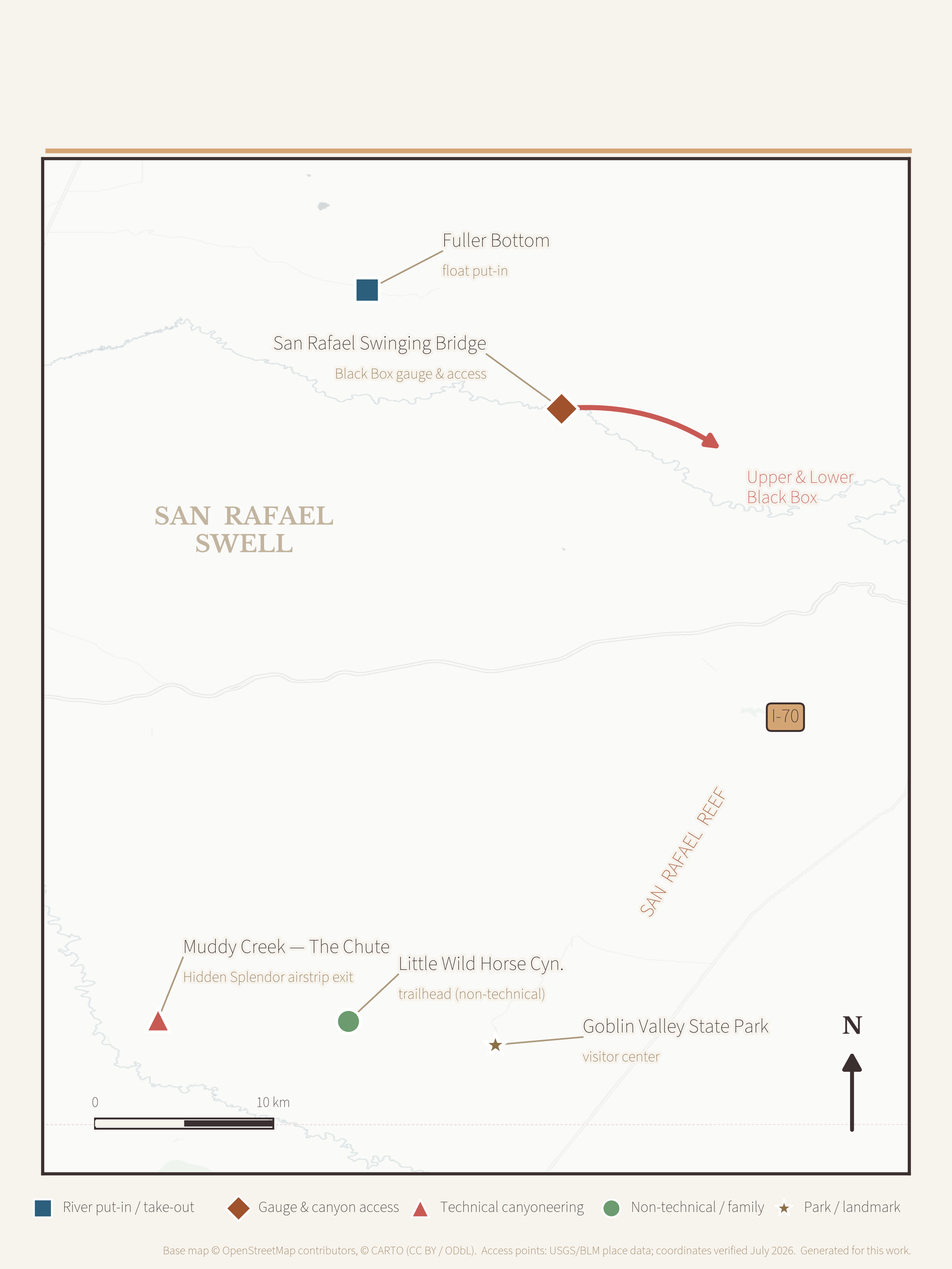
The San Rafael Swell is an oval-shaped dome of uplifted sedimentary rock roughly 75 miles long and 40 miles wide, occupying the western half of Emery County. Its eastern edge is defined by the San Rafael Reef, a tilted wall of Navajo and Wingate sandstone that rises abruptly from the desert floor like a row of jagged fins. Rivers and streams have sliced through this reef and through the interior of the Swell, creating a canyon system that rivals anything in southern Utah for technical challenge and sheer scenic drama.
The geology of the canyons is inseparable from their hazards. The same intermittent flooding that carved the narrows over millions of years can, in a matter of minutes, transform a dry slot into a roaring debris torrent. Flash floods originate not in the canyon itself but anywhere in the watershed above — sometimes ten to twelve miles away. A clear sky overhead offers no guarantee of safety if a thunderstorm is building over the plateau to the west (see Ch04: Climate & Weather ↗ 1 Ch04: Climate & Weather Climate as invisible architecture: precipitation, temperature, and weather patterns shaping life across Emery County's e... Read chapter → ).
Most canyons in the Swell require no advance permit for day use, managed by the BLM’s Price Field Office and Green River District as part of the San Rafael Swell Recreation Area (designated 2019). Dispersed camping on BLM land follows standard Leave No Trace protocols; fire pans are strongly encouraged and may be required in some corridors. The primary canyoneering corridors are described in the sections below.
Historical Context. The San Rafael Swell’s canyon network was known to Fremont culture people a thousand years before European contact, and to Ute and Paiute peoples thereafter. Spanish explorers and later American government surveyors skirted its edges without penetrating far. John Wesley Powell’s second expedition in 1871 reached the confluence of the San Rafael and Green Rivers; Powell and Stephen Vandiver Jones made a short inland excursion to examine the Reef (see Ch15: Powell Expeditions ↗ 3 Ch15: Powell Expeditions John Wesley Powell’s 1869 and 1871–72 voyages through Desolation Canyon and the Green River corridor: scientific mapping... Read chapter → ). Systematic exploration of the interior canyons came largely through necessity — uranium prospectors in the early twentieth century cut rudimentary roads across the Swell in search of ore, and those tracks became the access routes that canyoneers use today.
33.4 Black Box: The San Rafael River’s Technical Corridor
Few canyons in Utah carry a reputation as fearsome as the Black Boxes of the San Rafael River. The name refers to two distinct sections — Upper and Lower — where the San Rafael has cut deep, dark, narrow slots through the resistant limestone and sandstone of the Swell’s interior. The canyon walls block so much sky that, even at midday, the corridor feels subterranean, the light filtered to a dim green-grey that gives the route its unsettling name.
Upper Black Box is the more technical of the two routes. The preferred route covers approximately 4.1 miles and typically requires five to seven hours of continuous effort. Progress is slow because the route demands constant wading and swimming through pools of cold, often chest-deep water, combined with scrambling over chockstones and through tight constrictions. At least one rappel is required, with drops up to approximately 30 meters depending on water level and the party’s chosen line. This is not a hike — it is a full technical canyoneering undertaking that requires wetsuit gear in most seasons, experience with rappelling in water environments, and sound judgment about conditions.
The flash flood danger in the Upper Black Box is classified as very high by the BLM, and the record bears this out: several people have lost their lives in the canyon when flows surged without warning. The BLM recommends that parties check the water depth at the swinging bridge near the San Rafael Campground before entering either box. If the depth exceeds 2.5 feet, the canyon is off-limits. The maximum safe flow is approximately 50 cubic feet per second. These thresholds should be treated as absolutes, not as conservative suggestions.
Lower Black Box is less technical but is not benign. The corridor is wider and can be navigated without rappels at normal water levels, but its notorious flash flood potential has produced deaths when parties entered during elevated flows. Some canyoneers combine both boxes into a multi-day route, camping on the sandy benches between sections.
Did You Know? The San Rafael River drains nearly 700 square miles of high-plateau terrain before entering the Black Boxes. A localized thunderstorm over the Wasatch Plateau, thirty miles away, can send a wall of water through the narrows in less than an hour — faster than most parties can climb to safety.
Access. The standard Upper Black Box approach departs from Mexican Mountain Road (a rough dirt road requiring high-clearance vehicles) or from the San Rafael Campground area. A Utah Geological Survey GeoSights article on San Rafael Swell slot canyons provides detailed access information and safety guidance.
33.5 Muddy Creek and The Chute
If the Black Box is Emery County’s most technically demanding canyon, Muddy Creek’s “Chute” is its most deceptively difficult. Rated 2B IV — Basic Canyoneering, intermittent water, long and committing — the route requires no rappels and no technical rope skills, but its 15-mile length and the thick, clay-rich mud that coats the canyon floor have humbled many experienced backcountry travelers. The canyon contains three miles of true narrows where vertical walls rise hundreds of feet above the streambed, confining the route to a strip of water and rock that can be shoulder-width in places.
The route begins at the mouth of the Chute and follows Muddy Creek downstream through a series of wading pools, muddy scrambles, and brief swims before reaching the Hidden Splendor airstrip — a relic of the uranium boom, where ore was flown out of the Swell in the 1950s and 1960s (see Ch17: Coal, Copper & Uranium ↗ 3 Ch17: Coal, Copper & Uranium The extractive century: coal seams of the Wasatch Plateau, uranium-rich sandstones of the San Rafael Swell, copper bypro... Read chapter → ). The historical resonance of walking through wilderness canyon to emerge at a remote mining airstrip is one of the route’s unexpected pleasures.
Logistics. No permit is required. Plan for 8 to 14 hours in the canyon, depending on water levels and party pace; an overnight camp in the canyon is an option that many parties prefer. The BLM manages the corridor. Flash flood danger is real: the same weather caution that applies to all San Rafael Swell canyons applies here. Water sources in the canyon are silty and must be treated before drinking.
Key Hazard. The greatest risks in Muddy Creek are not technical — they are logistical. Parties routinely underestimate the time required, especially in high-water conditions when deep wading pools extend and mud thickness increases dramatically. Hypothermia from prolonged water immersion is a documented hazard in spring.
33.6 Wild Horse Canyon and Goblin Valley Slots
At the southern edge of the San Rafael Swell, near the Emery-Wayne County boundary, the terrain shifts from the massive limestone corridors of the Black Box and the muddy corridors of Muddy Creek to something more accessible: a suite of shallow, non-technical slot canyons that make an ideal introduction to canyon travel for families and beginners.
Little Wild Horse Canyon is the centerpiece. A classic of the genre, it threads through a maze of Entrada Sandstone narrows — constrictions so tight that adults must turn sideways to pass — for approximately three miles before opening into the broader Bell Canyon. Most visitors make the loop by climbing Little Wild Horse and descending Bell Canyon, a circuit of 8.1 miles that is rated moderately strenuous and requires four to six hours at a comfortable pace. No technical equipment is needed, though scrambling over car-sized boulders is part of the experience. The canyon is suitable for children who are comfortable with uneven terrain and occasional handholds.
The trailhead is located about six miles west of Goblin Valley State Park’s visitor center along a paved-then-gravel access road (no high-clearance vehicle required). Goblin Valley State Park (see Ch31: Parks & Monuments ↗ 5 Ch31: Parks & Monuments From Goblin Valley State Park to Jurassic National Monument: Emery County's four state parks, a BLM national monument, a... Read chapter → ) itself charges an entry fee for the park facilities; Little Wild Horse Canyon sits on adjacent BLM land and is free to enter, though parking at the trailhead is limited.
Ding and Dang Canyons offer additional slot experiences in the same vicinity. [Needs additional sources: technical details and access for Ding and Dang Canyons.]
Activity Idea — Youth Scavenger Hunt. Little Wild Horse Canyon’s narrows are a natural orientation exercise. Challenge young visitors to: (1) find the narrowest point they can fit through; (2) estimate the height of the canyon wall using only the width of their hand at arm’s length; (3) locate three different colors of sandstone; (4) find evidence that water has flowed here (water marks, smooth rock, embedded pebbles).
Flash Flood Warning. Little Wild Horse Canyon carries extreme flash flood potential despite its family-friendly reputation. The canyon drains a significant watershed. Do not enter if any rain is forecast anywhere in the region, and exit immediately if the sky darkens or water begins rising. The canyon’s popularity does not make it safe in adverse weather.
33.7 The San Rafael River Float
Every spring, for a window of perhaps two to three weeks, the San Rafael River becomes floatable. Snowmelt from the Wasatch Plateau charges the river with enough water to carry a canoe, kayak, packraft, or inflatable kayak through the Little Grand Canyon — a seventeen- mile stretch from Fuller Bottom to the Buckhorn Wash Bridge that offers some of the most dramatic scenery accessible from within Emery County.
The float is rated Class I with brief Class II ripples at normal spring flows. At 550 cfs (a typical high-spring volume), the run takes roughly six hours — the upper half moving quickly through open country, the lower half winding through tight meanders beneath Wingate sandstone walls that rise several hundred feet above the water. It is a river run that feels far more remote than the access roads would suggest.
Seasons and Flow. The window typically opens in late April and closes by early June, depending on snowpack and temperature. A minimum flow of 100 to 150 cfs is required to avoid dragging; below that threshold the river becomes too shallow to float continuously. USGS stream gauge data for the San Rafael River near Buckhorn Bridge should be checked before any trip. At flows below 100 cfs or above approximately 700 cfs, the river becomes respectively too shallow or too pushy for casual visitors.
The Transition to Technical Terrain. Floaters must take out at the Buckhorn Wash Bridge. Below that point, the river enters the Upper Black Box — a dramatically different proposition (see Section 33.4). The transition is swift and the canyon walls offer no easy escape once a boat has passed the bridge. This is not a mistake a party survives easily.
Camping. Dispersed camping is permitted on BLM land along the river corridor. Fire pans are strongly recommended; a portable toilet is required for overnight trips to comply with BLM Leave No Trace standards.
No permit is currently required for this section, though visitors should confirm current BLM regulations with the Price Field Office before launching, as management plans for the San Rafael Swell Recreation Area (designated 2019) are subject to revision.
33.8 Green River: Emery County’s Main Artery
The Green River enters Emery County from the north through Gray Canyon — a stretch of Class II–III whitewater flanked by the Book Cliffs — and exits southward into the flatwater meanders of Labyrinth Canyon. Between those two transitions lies the town of Green River, the county’s largest community on its eastern edge (population 847 at the 2020 census), which functions as the primary staging hub for all river travel in the region.
The town’s geography made this role inevitable. Situated where the river briefly eases onto a gravel-bedded floodplain between the two canyon sections, Green River has been a crossing and supply point since the transcontinental railroad arrived in the 1880s. Today it offers a state park boat ramp, motel and RV accommodations, vehicle shuttle services, outfitter supplies, and proximity to I-70 — all the practical infrastructure that river runners need.
Gray Canyon. The section of Green River immediately upstream of town — Gray Canyon — provides a half-day to full-day whitewater experience with Class II–III rapids, including the named Swasey’s Rapid. [Needs additional sources: complete rapid inventory and permit status for Gray Canyon.] The canyon’s Desolation and Gray Wild and Scenic River corridor begins here.
Green River State Park. Located within the town, this state park provides a paved boat launch, picnic facilities, camping, and a nine-hole golf course — the latter a distinctive contrast to the surrounding desert landscape. The park serves as the official launch point for Labyrinth Canyon trips.
33.9 Desolation and Labyrinth Canyons
Though both canyons extend beyond Emery County’s boundaries, both are most practically staged from the town of Green River — making them central to any visitor’s experience of the county as a river-running hub.
Labyrinth Canyon begins at the Green River State Park boat ramp in the town of Green River and extends 68 river miles south to Mineral Bottom (an alternate put-in at Ruby Ranch, 23 miles downstream, reduces the trip to 45 miles). The river through Labyrinth is flatwater throughout — no rapids, no whitewater, no technical skill required. What it offers instead is solitude at scale: towering canyon walls of Wingate sandstone rising from a river that moves at a walking pace, camp beaches at every bend, and a darkness at night that rivals any sky in North America. It is among the finest beginner multi-day paddling trips in the American West.
An overnight permit is required (free, obtained online via Recreation.gov); the corridor is jointly managed by the BLM Moab Field Office and the Utah Division of Forestry, Fire & State Lands. There is no cap on the number of permits issued. All parties must carry a fire pan and a portable toilet; group size is limited to 25 persons. The take-out at Mineral Bottom is reached via an unimproved road.
Desolation Canyon is a different order of commitment. The full route covers 84 river miles through Desolation and Gray Canyons — one of the longest and most remote river corridors in the lower 48 states. The river carries Class III rapids (Class IV at high water), passes through terrain with no road access for days at a time, and is listed as a National Wild and Scenic River. It is a wilderness river in the full sense of the word.
Did You Know? Major John Wesley Powell described Desolation Canyon in his 1869 expedition journal as “a region of the wildest desolation” — coining the name that has stuck for 150 years. Powell launched his first expedition from the town of Green River in May 1869.
A permit is required year-round for Desolation Canyon and is allocated through an annual lottery. Applications are accepted from December 1 through January 31 for the upcoming season; results are announced in mid-February; walk-up dates become available March 15 on Recreation.gov. Commercial launch dates are separate from the private lottery. The river is managed at a carrying capacity of approximately 35,000 user days per year, a limit established in the BLM Desolation/Gray River Management Plan. [Needs verification: confirm specific user-day cap and plan year against current BLM RMP.]
Table 33-B — River Runs of Emery County: A Comparison
| River — Section | Distance | Whitewater Class | Permit | Season | Put-in → Take-out |
|---|---|---|---|---|---|
| San Rafael River — Little Grand Canyon | 17 mi | Class I (brief Class II) | None for day use (confirm current BLM rules) | Late Apr–early Jun | Fuller Bottom → Buckhorn Wash Bridge |
| Green River — Gray Canyon | Half- to full-day | Class II–III | Part of Desolation/Gray corridor † | Spring–fall | Staged from the town of Green River |
| Green River — Labyrinth Canyon | 68 mi (45 mi via Ruby Ranch) | Flatwater (Class I) | Yes — free, self-issue | Spring–fall | Green River State Park → Mineral Bottom |
| Green River — Desolation & Gray Canyons | 84 mi | Class III (Class IV at high water) | Yes — annual lottery | Spring–fall | Staged from the town of Green River |
Distances, rapids classes, and permit types as described in §§33.7–33.9. Whitewater classes follow the American Whitewater International Scale of River Difficulty. Seasons reflect the chapter's seasonal calendar and are runoff-dependent. Sources: BLM Utah (Labyrinth Canyon River; Desolation/Gray permit system); American Whitewater (San Rafael; Labyrinth and Stillwater); USGS streamflow, San Rafael River near Buckhorn Bridge. † Gray Canyon's rapid inventory and standalone permit status are pending confirmation (see §33.8).
33.10 Safety, Flash Floods, and Emergency Response
The San Rafael Swell kills visitors every few years, and almost always through the same mechanism: a party in a canyon, a storm somewhere in the watershed, and a flood that arrives without warning. Flash floods are not rare events in the Swell — they are the defining hydrological process of the landscape. The canyon walls are as tall and smooth as they are because floods have been scouring them for millions of years.
Understanding this hazard is not optional for anyone traveling in Emery County’s canyon terrain. The following framework reflects BLM guidance and the consensus of experienced canyon travelers:
Before Entering Any Canyon:
- Check the full forecast for the entire watershed, not just the canyon mouth. A storm 10 to 12 miles upstream — invisible from the canyon — is sufficient.
- Consult a topographic map: understand how large the drainage is above your position. The San Rafael River drains nearly 700 square miles; even a 15-minute downpour over a small portion of that area can generate a dangerous flood.
- For the Black Boxes specifically, measure water depth at the swinging bridge near San Rafael Campground. Do not enter if depth exceeds 2.5 feet. Do not enter if flow exceeds 50 cfs.
- Identify your escape routes before committing to a technical section.
Inside the Canyon:
- If you hear a roaring sound upstream, or smell mud and organic debris, move to high ground immediately. Do not wait to see the water.
- A flash flood can arrive as a wall of water and debris moving faster than a sprint. There is no outrunning it in a slot canyon.
Emery County Search and Rescue (ECSAR / EMSAR) (see Ch29: Health, Safety & Emergency ↗ 4 Ch29: Health, Safety & Emergency From frontier midwives and the 1918 influenza pandemic through Castleview Hospital (1980, Level IV Trauma 2023) and Emer... Read chapter → ) responds to incidents throughout the San Rafael Swell and the Manti-La Sal mountain terrain. The team is composed of volunteers from law enforcement, public safety, fire, healthcare, and EMS. Cell coverage in the Swell is largely absent; a satellite communicator (SPOT, Garmin inReach, or equivalent) is not a luxury in this terrain — it is the difference between a self-rescue and a recovery. Contact EMSAR at emsar.org. In emergencies, call 911 and request Emery County SAR.
Sidebar — Family Activity: Flash Flood Safety Check. Before entering any canyon with children, practice the “go/no-go” decision together as a family. Review the weather forecast, identify the canyon’s watershed on a map, and discuss what each person should do if water begins rising. Making this a routine conversation teaches canyon safety as a habit rather than a warning.
33.11 Permits, Access, and Leave No Trace
Emery County’s outdoor recreation areas are managed by a patchwork of agencies, each with its own permit requirements and access rules. The table below summarizes the key areas covered in this chapter.
| Area | Agency | Permit Required | Fee |
|---|---|---|---|
| Joe’s Valley Bouldering | BLM / Manti-La Sal NF | No | Campground: $15/night |
| San Rafael Swell (day use) | BLM Price / Green River | No (most areas) | None |
| Upper Black Box | BLM Price / Green River | No (day use) | None |
| Muddy Creek / The Chute | BLM Price / Green River | No | None |
| Little Wild Horse Canyon | BLM / adjacent to Goblin Valley SP | No | None |
| San Rafael River Float | BLM Price / Green River | No (confirm current rules) | None |
| Labyrinth Canyon | BLM Moab Field Office | Yes (free, self-issue) | None |
| Desolation/Gray Canyon | BLM Price Field Office | Yes (lottery) | Recreation.gov fee |
| Goblin Valley State Park | Utah State Parks | Yes (entry fee) | Per-vehicle |
Leave No Trace Principles apply throughout Emery County’s public lands. Key requirements:
- Pack out all waste, including human waste on river trips (portable toilet required on Labyrinth and Desolation Canyon runs)
- Use a fire pan for all campfires on river corridors; check current fire restrictions
- Camp at least 200 feet from water, trails, and other campers
- Do not build cairns or mark routes in canyon terrain — this alters the experience for other visitors and can mislead future travelers
- At Joe’s Valley: never climb wet sandstone; respect the 24–48 hour post-rain waiting period; remove all chalk marks that are visible from a distance
Access Roads. Many San Rafael Swell trailheads require high-clearance vehicles. The Mexican Mountain Road (Black Box access), the Wedge Overlook Road, and most Muddy Creek access points are passable by high-clearance 4WD in dry conditions and impassable when wet. Clay-heavy desert soils turn to glue in rain. Check road conditions with the BLM Price Field Office (435-636-3600) before driving dirt roads after any precipitation.
33.12 Planning Your Visit
Gateway Towns. Castle Dale (county seat) and Orangeville are the closest towns to Joe’s Valley and the northern Swell canyons; Green River serves the eastern Swell and all river runs. Price (Carbon County) is 30–60 minutes north and provides the largest selection of lodging, restaurants, gear shops, and emergency services.
Skill Level Guide:
| Activity | Minimum Skill Level | Recommended Experience |
|---|---|---|
| Joe’s Valley bouldering (V0–V3) | None | Basic fitness; pad recommended |
| Little Wild Horse Canyon | None | Comfortable on uneven terrain |
| San Rafael River Float | Beginner paddler | Basic boat control; swimming ability |
| Labyrinth Canyon | Beginner paddler | Multi-day camping; navigation |
| Upper Black Box | Intermediate canyoneer | Rappelling, swimming, wetsuit use |
| Muddy Creek / The Chute | Intermediate canyoneer | Navigation, endurance, cold water |
| Desolation Canyon | Advanced paddler | Class III whitewater; self-rescue |
Seasonal Calendar:
| Month | Joe’s Valley | Canyon Routes | San Rafael Float | Green/Labyrinth |
|---|---|---|---|---|
| Jan–Feb | Cold; possible | Weather-dependent | Too low | Too cold |
| Mar–Apr | Prime | Good (pre-monsoon) | Building | Good |
| May–Jun | Warm; OK | Good early | Peak (Apr–May) | Good |
| Jul–Aug | Too hot | Flash flood season | Too low | Hot; possible |
| Sep–Oct | Prime | Prime | Too low | Prime |
| Nov–Dec | Cooling; possible | Weather-dependent | Too low | Possible |
Recommended Outfitters and Resources. Several outfitter companies hold BLM commercial use permits for tours in the region, including river trips on the Green River and guided canyoneering in the San Rafael Swell. The Utah Guides and Outfitters Association (utah-adventures.com) maintains a current list of licensed operators. [Needs additional sources: Emery County-based guide services specifically — currently only regional outfitters confirmed.]
For bouldering, the KAYA Pro digital guidebook by Steven Jeffery (kayaclimb.com/joes-valley) is the most comprehensive current resource for Joe’s Valley. Mountain Project (mountainproject.com) provides free crowd-sourced route information.
For all BLM land: Price Field Office, 125 South 600 West, Price, UT 84501 — phone 435-636-3600. Green River District Office: 170 South 500 East, Green River, UT 84525 — phone 435-564-3170.
See Also
- Ch30: Landscapes of Adventure ↗ 5 Ch30: Landscapes of Adventure A practical field guide to Emery County's adventure landscape: San Rafael Swell slot canyons and OHV routes, Goblin Vall... Read chapter →
- Ch32: Trails & Routes ↗ 5 Ch32: Trails & Routes The complete trail grammar of Emery County: Buckhorn Wash Scenic Backway, Little Wild Horse and Bell Canyon slot-canyon ... Read chapter →
- Ch34: Wildlife Watching ↗ 5 Ch34: Wildlife Watching A field guide to wildlife observation across Emery County's three habitat zones - the Wasatch Plateau high country, the ... Read chapter →
- Ch35: Night Sky Tourism ↗ 5 Ch35: Night Sky Tourism Dark skies as Emery County's emerging tourism resource: Goblin Valley State Park's 2016 International Dark Sky designati... Read chapter →
- Ch36: Travel & Logistics ↗ 5 Ch36: Travel & Logistics The practical infrastructure of visiting Emery County: I-70's longest service-station gap in the lower 48 (the 'fill up ... Read chapter →
Further Reading & Links
- BLM Utah — Joe’s Valley Bouldering Area — Land-manager page for the bouldering area and its two BLM campgrounds (New Joe’s, Cottonwood Canyon), with directions and contact information.
- BLM Utah — Labyrinth Canyon River — Official trip-planning and free self-issue permit page for the flatwater Green River run from the town of Green River to Mineral Bottom.
- BLM Utah — Desolation / Gray (Green River) Permit — Overview and lottery-permit gateway for the wilderness Desolation and Gray Canyon river corridor.
- USGS — San Rafael River near Green River, Utah (gauge 09328500) — Real-time streamflow data (cfs) to check before floating the Little Grand Canyon or entering the Black Boxes.
- Utah Geological Survey — GeoSights — UGS public-geology feature series, including the slot canyons of the San Rafael Swell, with access and safety guidance.
Sources
- BLM Utah. “Joe’s Valley Bouldering Area.” blm.gov/visit/joes-valley-bouldering-area
- BLM Utah. “Labyrinth Canyon River.” blm.gov/visit/labyrinth-canyon-river
- BLM Utah. “Desolation Gray — Green River Permit.” blm.gov/visit/desolation-gray-green-river-permit
- BLM Utah. “Desolation Gray Canyons River Permit System.” blm.gov/programs/recreation/passes-and-permits/lotteries/utah/desolationgray
- Utah Geological Survey. “GeoSights: Slot Canyons of the San Rafael Swell, Emery County.” geology.utah.gov
- Joe’s Valley Fest. “Guide to Joe’s Valley.” joesvalley.org/guide-to-joes-valley
- KAYA Climb. “Joe’s Valley Bouldering Guide: How, When, and Where.” blog.kayaclimb.com
- Climbing.com. “The Big Easy: An Insider’s Guide to Joe’s Valley Bouldering.” climbing.com
- climb-utah.com. “Upper Black Box — San Rafael Swell.” climb-utah.com/SRS/ubb.htm
- climb-utah.com. “Lower Black Box — San Rafael Swell.” climb-utah.com/SRS/lbb.htm
- climb-utah.com. “The Chute of Muddy Creek.” climb-utah.com/SRS/thechute.htm
- canyonslimit.com. “Muddy Creek ‘The Chute’ (2BIV).” canyonslimit.com
- americansouthwest.net. “Muddy Creek, San Rafael Swell, Utah.”
- Road Trip Ryan. “Canyoneering Upper Black Box — San Rafael Swell.”
- Road Trip Ryan. “Floating Little Grand Canyon — Northern Swell.” roadtripryan.com
- Bearfoot Theory. “How to Float the San Rafael River in Utah.” bearfoottheory.com
- AllTrails. “The Chute of Muddy Creek.” alltrails.com
- AllTrails. “Wildhorse Canyon (via Goblin Valley State Park).” alltrails.com
- Utah.com. “Little Wild Horse Canyon.”
- Visit Utah. “A Guide to the Many Faces of Utah’s Green River.” visitutah.com
- Visit Utah. “Adventure Towns — Green River Float Trips.” visitutah.com
- Wikipedia. “Joe’s Valley.” en.wikipedia.org/wiki/Joe%27s_Valley
- Wikipedia. “San Rafael Swell.” en.wikipedia.org/wiki/San_Rafael_Swell
- American Whitewater. “San Rafael (Bridge at San Rafael Campground to I-70).”
- American Whitewater. “Labyrinth and Stillwater Canyons.”
- EMSAR — Emery County Search and Rescue. emsar.org
- Castle Country Radio. “Emery County SAR rescues man, dog after rappelling fall in San Rafael Swell.” castlecountryradio.com (May 11, 2026)
- UEN Utah History Encyclopedia. “The San Rafael Swell.” uen.org
- Utah Geological Survey. “Powell’s 1869 Journey Down the Green and Colorado Rivers.” geology.utah.gov
Proposed Maps and Figures
- Map — Joe’s Valley Overview: Bouldering zones (Left Fork, Right Fork, New Joe’s), campground locations, SR-29 access from Orangeville. Scale 1:20,000.
- Map — San Rafael Swell Canyoneering: Black Box (Upper/Lower) approach roads, Muddy Creek/Hidden Splendor, Little Wild Horse trailhead, Buckhorn Wash Bridge, I-70 corridor. Scale 1:200,000.
- Map — Green River Corridor: Green River town boat ramp, Labyrinth Canyon put-in/take-out (Mineral Bottom), Gray Canyon extent, Desolation Canyon staging.
- Photo — Joe’s Valley: Sandstone boulder with climber (scale reference); texture detail closeup.
- Photo — Black Box: Corridor interior, narrow walls, light quality.
- Photo — Muddy Creek Narrows: Wall height comparison with person.
- Photo — Little Wild Horse: Slot passage with family visitor for scale.
- Infographic — Flash Flood Decision Framework: Weather check → watershed map → BLM gauge → go/no-go. Suitable for sidebar or pull-quote.
Proposed Tables
- Table 33-A — Canyon Route Comparison: Canyon, length, technical rating, permit required, season, key hazards, access road type.
- Table 33-B — River Run Comparison: River, section, miles, class, permit, season, put-in/take-out, outfitter options.
- Table 33-C — Monthly Activity Calendar: Month-by-month go/no-go matrix for all major activities.
- Table 33-D — Agency Contact Information: BLM offices, state park, EMSAR, outfitters.
Engagement Features
Did You Know?
- The roads crisscrossing the San Rafael Swell were not built for recreation. Most were scraped into the desert by uranium prospectors during the 1950s boom, when the Atomic Energy Commission paid premium prices for ore and turned sheepherders into part-time miners overnight. Without those roads, modern canyon access would be far more difficult.
- Bouldering grades use the “V scale,” invented by Colorado climber John “The Verm” Sherman in the 1990s. V0 is about the difficulty of a standard rock-gym beginner route; V13 represents the outer edge of human performance. Joe’s Valley has confirmed problems across the entire spectrum.
- The San Rafael River drains nearly 700 square miles of high-plateau terrain before entering the Black Boxes. A localized thunderstorm over the Wasatch Plateau, thirty miles away, can send a wall of water through the narrows in less than an hour — faster than most parties can climb to safety.
- Major John Wesley Powell described Desolation Canyon in his 1869 expedition journal as “a region of the wildest desolation” — coining the name that has stuck for 150 years. Powell launched his first expedition from the town of Green River in May 1869.
Family Activity — Flash Flood Safety Check
Before entering any canyon with children, practice the “go/no-go” decision together as a family. Review the weather forecast for the entire watershed (not just the canyon mouth), identify the canyon’s drainage area on a topographic map, locate the BLM streamflow gauge online, and discuss what each person should do if water begins rising. Making this a routine pre-trip conversation teaches canyon safety as a habit rather than a one-time warning — and it gives children a sense of agency in a landscape that can otherwise feel overwhelming.
Youth Challenge — Little Wild Horse Slot Scavenger Hunt
Little Wild Horse Canyon’s narrows are a natural orientation exercise. Challenge young visitors to:
- Find the narrowest point they can fit through (and have an adult photograph the moment).
- Estimate the height of the canyon wall using only the width of their hand at arm’s length — then check the answer against a topographic map at home.
- Locate three different colors of sandstone in the canyon walls; sketch each in a notebook.
- Find evidence that water has flowed here — water marks, polished rock, embedded pebbles, logs lodged in cracks above head height.
- Count the number of curves in the slot section. Compare with a sibling or friend — disagreements about what counts as a curve are part of the fun.
Field Trip — A Weekend in the Swell (Two-Day Itinerary)
Day 1 — Joe’s Valley to the Black Box Overlook. Begin in Orangeville with breakfast at a local café. Drive west on SR-29 to Joe’s Valley; spend the morning at the New Joe’s bouldering area (no equipment needed — observation only is fine). Picnic at the reservoir. In the afternoon, drive south to the Wedge Overlook area and view the Little Grand Canyon from above. Camp at the San Rafael Campground (BLM, first-come, first-served).
Day 2 — Buckhorn Wash and Little Wild Horse. Begin at the San Rafael Swinging Bridge: read the depth gauge as a teaching moment. Drive south through Buckhorn Wash to view rock art and the Wedge approach roads. Continue to the Little Wild Horse trailhead (about six miles west of Goblin Valley State Park’s visitor center) and hike the Little Wild Horse / Bell Canyon loop (8.1 miles, four to six hours). Return to Castle Dale via SR-24 and I-70.
What to pack: Three liters of water per person per day; first-aid kit; topographic map; sun protection; a satellite communicator (Garmin inReach or equivalent); cash for campground self-pay fee tubes.
Photo Assignment — The Swinging Bridge Gauge
The San Rafael Swinging Bridge near the San Rafael Campground bears a painted depth gauge that marks the threshold (2.5 feet) above which the Black Box becomes off-limits. Photograph this gauge: the painted markings, the river surface at current level, and the bridge structure itself. The image is a useful reference for future trip planning and a tangible record of why the canyon’s hazards demand respect. Submit your photograph to the encyclopedia’s reader-contribution archive at the address listed in Ch41 (Further Reading).