Part 1 · Foundations
Night Skies & Astronomy
Dark skies and celestial wonders: constellations, milky way viewing, and the astronomical heritage of the high desert.
Ch07 — Night Skies & Astronomy
The same qualities that make Emery County a challenging place to live — its remoteness, its aridity, its sparse population scattered across 4,472 square miles — make it one of the finest places in the continental United States to see the universe. When the sun sets over the Wasatch Plateau and the last glow fades from the San Rafael Reef, the sky above Emery County opens into a depth of darkness that most Americans have never experienced. The Milky Way arcs overhead bright enough to cast shadows on the ground. The zodiacal light — that faint pyramid of sunlight scattered off interplanetary dust — rises from the horizon like a second sunset. Deep-sky objects that most people know only from Hubble photographs resolve to the naked eye. This chapter maps the county’s night sky as both a natural resource and an emerging economic asset, connecting the atmospheric science of Chapter 4, the nocturnal ecology of Chapter 6, and the practical field-guide itineraries of Part V.
7.1 Bortle Zones & Dark-Sky Quality
The darkness of a night sky is measured on the Bortle Scale, a nine-level classification system published by amateur astronomer John Bortle in Sky & Telescope magazine in February 2001. Class 1 represents the darkest skies achievable on Earth — locations where the zodiacal light, gegenschein, and zodiacal band are all visible, and where the limiting naked-eye magnitude exceeds 7.6. Class 9 describes the washed-out glow of a city center where only the Moon, planets, and a handful of bright stars penetrate the artificial glare.
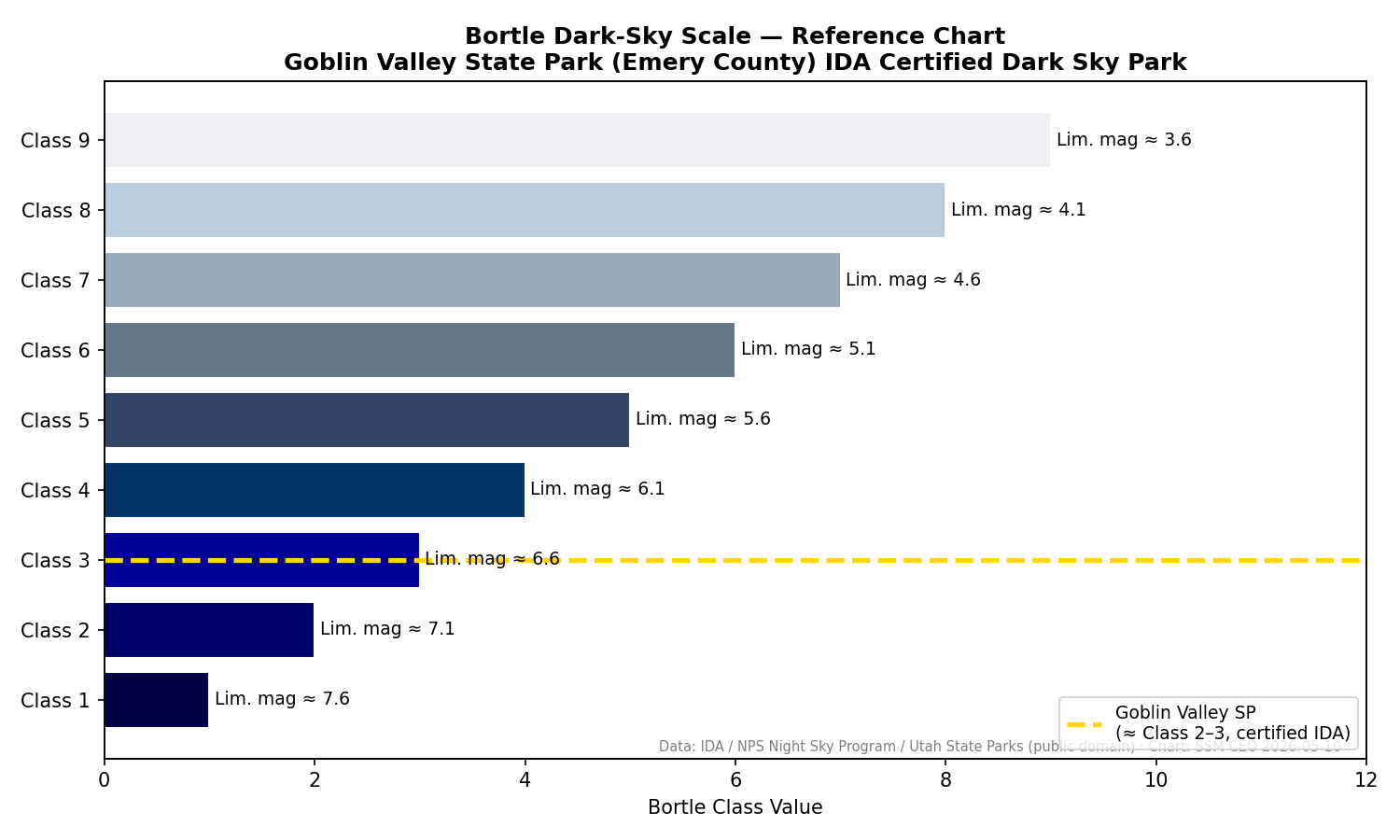
Emery County contains some of the darkest measured skies in North America. In 2015, the National Park Service Night Sky Team assessed Goblin Valley State Park in southern Emery County and determined that it possesses “one of the darkest night skies on earth.” The following year, Goblin Valley was designated an International Dark Sky Park by DarkSky International, joining an elite group of sites worldwide recognized for exceptional darkness and active light-pollution prevention. On the Bortle Scale, Goblin Valley rates Class 1 to Class 2 — the precise rating varies by source and measurement conditions, but all assessments place it among the darkest accessible sites in the lower 48 states (DarkSky International; Utah State Parks; NPS Night Sky Program).
A more precise instrument is the Sky Quality Meter (SQM), which measures sky brightness in magnitudes per arcsecond squared (mag/arcsec²). Higher values indicate darker skies; a pristine Bortle Class 1 site typically reads 21.7 to 22.0+ mag/arcsec². The NPS Night Sky Team uses a robotic camera system — mounted on a Meade LX 200GPS telescope that captures 104 images stitched into a full-sky mosaic — to produce calibrated brightness maps across the national park system. These measurements confirm that the Colorado Plateau, including the lands surrounding Emery County, consistently produces some of the lowest artificial sky-glow readings in the contiguous United States.
The darkness is not uniform across the county. The San Rafael Swell interior, accessible only by unpaved roads and far from any settlement, likely achieves the darkest readings. The towns of Castle Dale, Huntington, and Green River produce modest light domes visible from surrounding terrain, but their small populations and limited commercial lighting mean these domes dissipate within a few miles. Even from within town limits, the Milky Way is visible on clear nights — an experience that has become extraordinary in a nation where an estimated 80 percent of Americans can no longer see the Milky Way from where they live.
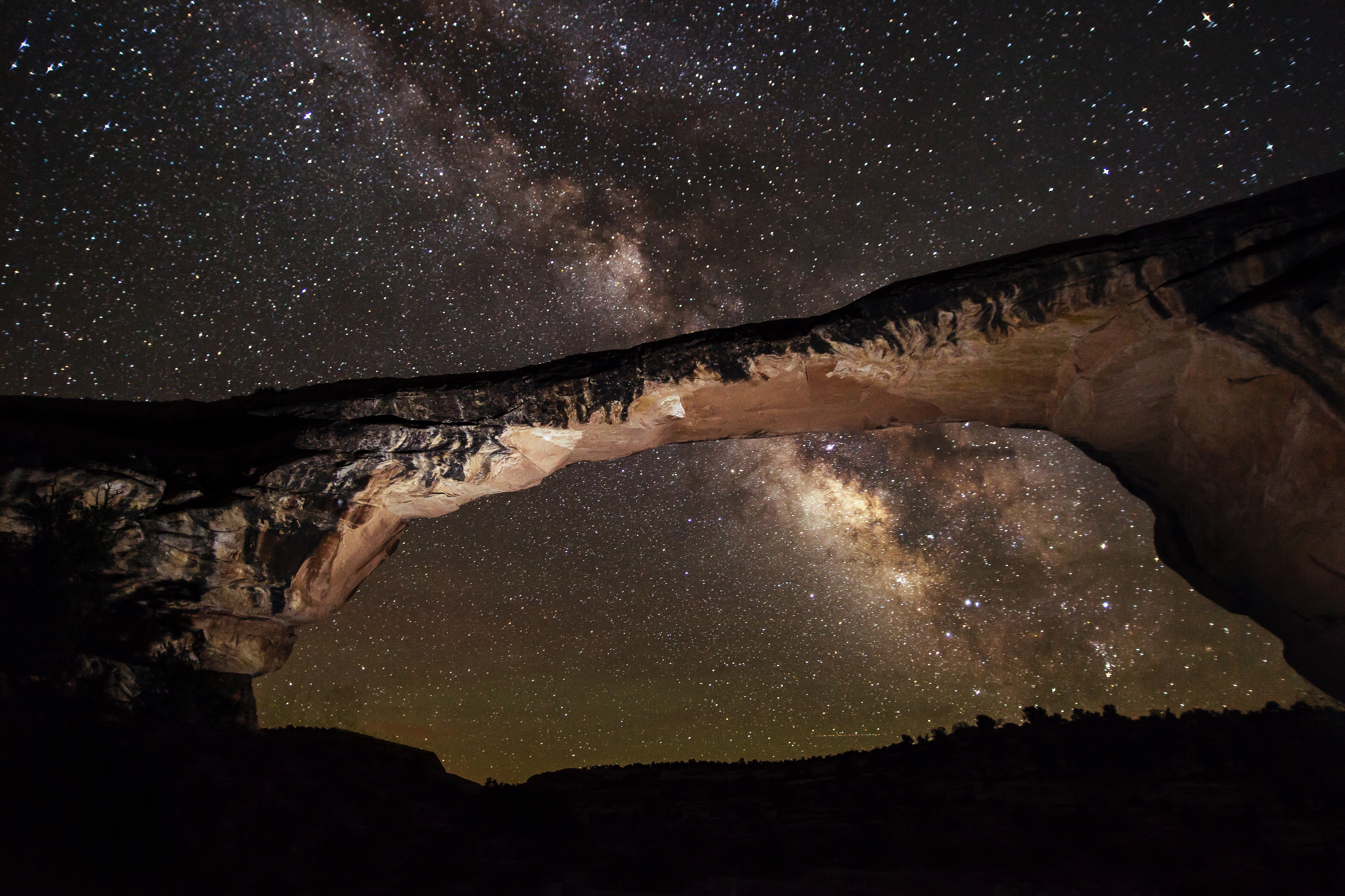
From Goblin Valley State Park on a moonless summer night, the Milky Way is bright enough to cast faint shadows on the ground. An estimated 80 percent of Americans live under skies too bright to see the Milky Way at all — a threshold crossed sometime in the late twentieth century as electric light spread across the country. Coming to Emery County is, for many visitors, the first time they have ever seen the sky as it appeared to every human being who lived before electric light.
7.2 Seasonal Constellation Guide
Emery County’s latitude — approximately 39° North — places it in a favored position for observing both northern and equatorial constellations. The celestial pole, marked by Polaris, sits roughly 39 degrees above the northern horizon, while the southern horizon grants access to constellations as far south as declination −51°, including Sagittarius, Scorpius, and the rich star fields of the galactic center.
Spring (March–May): The winter constellations — Orion, Taurus, Gemini — sink toward the western horizon after sunset and are replaced by Leo, Virgo, and Boötes climbing from the east. The Big Dipper rides high overhead, and its pointer stars lead to Polaris. Spring evenings are the best time to observe galaxies: the Virgo Cluster, a concentration of more than 1,300 galaxies roughly 54 million light-years away, passes nearly overhead and is accessible with binoculars from Emery County’s dark skies.
Summer (June–August): The galactic center rises in the southeast after dark, and the Milky Way spans the sky from Sagittarius through the Summer Triangle — Vega, Deneb, and Altair. This is the premier season for Milky Way photography and naked-eye observation. The Lagoon Nebula, the Eagle Nebula, and the Trifid Nebula are all visible in binoculars against the rich star fields of Sagittarius. Jupiter and Saturn frequently inhabit the summer sky, their brightness rivaling the brightest stars.
Autumn (September–November): The Milky Way tilts westward as the Summer Triangle descends, and the Great Square of Pegasus dominates the eastern sky. The Andromeda Galaxy — the most distant object visible to the naked eye at 2.5 million light-years — is well-placed for observation, appearing as a faint smudge of light in a dark-sky site like the San Rafael Swell. The autumn sky is often the steadiest, with calm, dry conditions after the monsoon season producing excellent seeing.
Winter (December–February): The richest constellation field of the year fills the sky. Orion the Hunter strides across the south, his belt pointing down to Sirius (the brightest star in the night sky) and up to Aldebaran and the Pleiades cluster. Gemini, Auriga, and Canis Major complete a dazzling arc of bright stars. Winter nights are long — over 14 hours of darkness at the solstice — and the cold, dry air produces exceptional transparency, though observers must dress for temperatures that can drop well below zero on the valley floor.
7.3 Milky Way Viewing Windows
The Milky Way’s galactic core — the brightest and most photogenic section, centered on the constellation Sagittarius — is visible from Emery County from approximately late March through early October. The core rises in the southeast shortly before dawn in March, gradually shifting earlier until it is visible all night in June and July, then sinking into the southwest after sunset by September.
The optimal Milky Way viewing window runs from late May through mid-August, when the galactic center reaches its highest altitude above the southern horizon during the dark hours. During this window, the core arcs dramatically overhead from a dark site in the San Rafael Swell, and its structure — the dark dust lanes of the Great Rift, the bright star clouds of Scutum and Sagittarius, the subtle glow of the galactic bulge — is visible in extraordinary detail to the unaided eye.
Moon phase is the critical variable. The galactic core is best observed during the week surrounding new moon, when moonlight does not wash out the fainter structure. A full moon, even from a Bortle Class 1 site, reduces the Milky Way to a pale band and eliminates most of the detail that makes dark-sky observation worthwhile. Planning a visit around the lunar calendar is essential for anyone traveling to Emery County specifically for stargazing.
7.4 Major Meteor Showers & Peak Dates
Emery County’s dark skies and wide-open horizons make it an exceptional location for meteor shower observation. Unlike telescopic astronomy, meteor watching requires no equipment — only patience, a reclining chair or blanket, and freedom from light pollution. The county provides all three in abundance.
The year’s major showers, with approximate 2026 peak dates and conditions:
The Quadrantids (January 3–4) produce up to 120 meteors per hour at peak but have an unusually narrow window of only a few hours. Cold January nights in Castle Valley, with temperatures near or below zero, make this a test of dedication.
The Lyrids (April 22–23) are a modest shower at roughly 18 meteors per hour, but they mark the first warm-weather observing opportunity and occasionally produce bright fireballs.
The Eta Aquariids (May 5–6), debris from Halley’s Comet, produce around 30 meteors per hour and are best viewed in the pre-dawn hours when the radiant rises above the southeastern horizon.
The Perseids (August 12–13) are the year’s most reliable show, consistently delivering 100 or more meteors per hour. In 2026, the Perseids peak during a new moon — optimal conditions that occur only every few years. This is arguably the single best night of the year to visit Emery County for astronomical observation. The warm August temperatures and the coincidence of peak Milky Way season make the Perseids a natural anchor for an astrotourism visit.
The Geminids (December 13–14) rival the Perseids in intensity, with 100 or more meteors per hour, and have the advantage of being active all night rather than peaking only after midnight. In 2026, a waxing crescent moon sets early, leaving the sky dark through the prime viewing hours. December cold is the main deterrent.
2026 Meteor Shower Calendar
| Shower | Peak Night | Max/Hour | 2026 Moon |
|---|---|---|---|
| Quadrantids | Jan 3–4 | ~120 (narrow) | Check calendar |
| Lyrids | Apr 22–23 | ~18 | Check calendar |
| Eta Aquariids | May 5–6 | ~30 | Check calendar |
| Perseids | Aug 12–13 | 100+ | New moon — optimal |
| Geminids | Dec 13–14 | 100+ | Crescent, sets early |
Moon phase is the most critical planning variable for meteor watching. The 2026 Perseids peak during a new moon — optimal conditions that occur only every few years and that coincide with peak Milky Way season.
In 2026, the Perseid meteor shower peaks August 12–13 during a new moon — optimal viewing conditions that occur only every few years. From a Bortle Class 1 site in the San Rafael Swell, observers can expect 100 or more meteors per hour against a Milky Way detailed enough to see the dark dust lanes of the Great Rift with the naked eye. The August coincidence of peak shower, dark moon, and galactic center directly overhead makes this one of the best stargazing nights in a generation for Emery County visitors.
7.5 Planetary Alignments & Ecliptic Watching
The ecliptic — the plane of the solar system projected onto the sky — crosses Emery County’s southern horizon at a favorable angle. The planets, which always lie near the ecliptic, are well-positioned for observation throughout the year, and the county’s dark skies enhance the contrast of fainter planets like Saturn, Mars, and (through binoculars) Uranus and Neptune.
Jupiter and Saturn are the premier targets for observers with binoculars or small telescopes. Jupiter’s four Galilean moons — Io, Europa, Ganymede, and Callisto — are visible as tiny points of light flanking the planet in steadily held binoculars. Saturn’s rings, visible through any telescope at 30x or higher magnification, are among the most awe-inspiring sights in amateur astronomy and are especially striking when the rings are tilted toward Earth. Venus, the brightest planet, dominates the western sky after sunset or the eastern sky before dawn depending on its orbital position, and frequently draws inquiries from visitors unfamiliar with its brilliance.
Planetary conjunctions — close apparent approaches between two or more planets — occur several times per year and provide natural opportunities for public outreach and astrotourism promotion. These events are predictable years in advance and can be incorporated into seasonal marketing for Emery County’s dark-sky destinations.
7.6 Archaeoastronomy
The night sky was not merely background to the ancient peoples of the Colorado Plateau; it was a practical tool for timekeeping, agriculture, and ritual. The Fremont culture, which occupied much of what is now Emery County from approximately AD 300 to 1300, left evidence of celestial awareness in their rock art — though the extent to which specific Emery County sites encode astronomical alignments remains an active and under-studied question.
Across the Colorado Plateau, documented archaeoastronomical features include petroglyphs and pictographs that interact with sunlight or shadow at solstices and equinoxes. The most famous example is the Sun Dagger at Chaco Canyon in New Mexico, where a spiral petroglyph is bisected by a dagger of sunlight at the summer solstice. Closer to Emery County, researchers have documented a Fremont-era pictograph in east-central Utah — a 90-centimeter red ochre anthropomorph with a V-shaped headdress — that is illuminated by sunlight at the summer solstice for a seven-day period, dated to approximately AD 1100–1300 (Journal of Skyscape Archaeology).
The San Rafael Swell’s abundant rock art panels — created by both Fremont and Archaic peoples — are a promising but largely uninvestigated source of potential archaeoastronomical alignments. The Swell’s dramatic cliff faces and alcoves create natural light-and-shadow interactions that ancient peoples could have exploited for calendrical purposes. Systematic surveys combining rock art documentation with solar/lunar position modeling could yield significant discoveries.
[needs additional sources] Specific archaeoastronomy inventory for Emery County rock art sites has not been located. Collaboration with the BLM Price Field Office, which manages most of the Swell’s rock art, and with archaeoastronomy researchers at Utah universities would be valuable.
Somewhere in east-central Utah, a Fremont pictograph painted in red ochre roughly 900 years ago — a 90-centimeter figure with a distinctive V-shaped headdress — is illuminated by a dagger of sunlight for exactly seven days around the summer solstice, then goes dark again. Dated to approximately AD 1100–1300, it is one of only a few confirmed solstice markers on the Colorado Plateau. The San Rafael Swell's dramatic cliffs and alcoves make it a promising landscape for additional discoveries — most of its rock art panels have never been surveyed for astronomical alignments.
7.7 Astrophotography Hotspots & Techniques
Emery County’s combination of dark skies, dramatic foregrounds, and accessible locations makes it a destination for astrophotographers ranging from smartphone snappers to professionals with tracking mounts and cooled cameras.
Goblin Valley State Park is the county’s premier astrophotography location. The hoodoos and mushroom-shaped rock formations provide surreal foreground subjects that compose naturally against the Milky Way. The park’s flat, open terrain allows unobstructed views from horizon to horizon, and the campground provides a convenient base. Best months: June through September for Milky Way compositions.
The San Rafael Reef — the dramatic upturned sandstone ridge that forms the eastern edge of the San Rafael Swell — offers towering rock walls and natural arches that frame the sky. Locations along the I-70 corridor where the Reef is visible provide roadside access for photographers who prefer not to hike in darkness.
Temple Mountain and the Swell interior — reached via unpaved roads from Highway 24 — provide complete 360-degree dark horizons with virtually no artificial light in any direction. The elevation (5,000–6,000 feet depending on location) reduces atmospheric haze compared to the lower Green River valley.
Huntington Canyon and the Wasatch Plateau offer higher-elevation sites (~8,000–10,000 feet) where atmospheric transparency is maximized, though access roads may be snow-covered from October through May.
For beginners, modern smartphones with night mode can capture recognizable Milky Way images from Bortle 1–2 sites — a revelation for visitors accustomed to light-polluted skies. For dedicated astrophotographers, the standard wide-field technique uses a 14–24mm lens at f/2.8, ISO 3200–6400, with exposures of 15–25 seconds on a fixed tripod (using the “500 Rule” to limit star trailing). A star tracker mount extends exposure times to minutes, revealing nebular detail invisible in single frames.
Milky Way Self-Portrait
- Your subject
- Your silhouette beneath the Milky Way's galactic core — arms outstretched, facing the camera, with the star fields of Sagittarius arcing overhead
- Where to find it
- What to look for
- The story you're telling
- More than 80 percent of Americans live under skies bright enough to erase the Milky Way. This photo is proof that the sky this chapter describes is real — and that you stood beneath it.
Share your photo with #EmeryEncyclopedia
7.8 Community Star Parties & Telescope Facilities
Organized astronomical activity in Emery County is modest but growing. Goblin Valley State Park, as an International Dark Sky Park, is committed to providing night-sky educational programs as a condition of its designation. Park rangers lead seasonal astronomy programs that may include telescope viewing, constellation tours, and night-sky interpretation.
The nearest established amateur astronomy community is in the Wasatch Front urban corridor, 100 or more miles to the northwest. However, Utah’s statewide dark-sky enthusiasm — fueled by the state parks initiative and Visit Utah’s astrotourism marketing — has generated interest in stargazing events across rural Utah. Pop-up star parties organized by amateur astronomers, school groups, or tourism organizations represent an opportunity for Emery County communities to develop programming that leverages their natural dark-sky advantage.
USU Eastern (formerly the College of Eastern Utah) in Price, roughly 30 miles north of Castle Dale, is a potential partner for astronomy outreach. Whether the campus maintains a telescope or offers astronomy coursework is a question worth investigating.
[needs additional sources] Specific data on organized star parties, astronomy club activity, or telescope facilities in Emery County has not been located. Goblin Valley ranger program schedules should be consulted for current offerings.
7.9 Light Pollution Sources & Mitigation
Emery County’s dark skies exist not because someone protected them but because so few people live here. The county’s population of approximately 10,000 produces minimal artificial light, and the absence of large commercial or industrial installations means there is no significant sky glow from within the county’s borders. But darkness is not permanent. It is a resource that can be lost incrementally, and the threats — though currently small — are worth identifying.
The primary light sources within the county are the towns themselves. Castle Dale, Huntington, Orangeville, Ferron, and Green River each produce a modest light dome visible from dark sites several miles away. Unshielded streetlights, security lighting on agricultural buildings, and commercial signage are the main contributors. The Interstate 70 corridor adds highway lighting and vehicle headlights that create a linear light signature across the county’s southern tier.

Energy development poses a potential future threat. The Uinta Basin to the north already produces a visible light dome from natural gas flaring and well-pad lighting. If energy development were to expand significantly within Emery County — whether fossil fuel extraction or large-scale solar installations with security lighting — the impact on dark-sky quality could be substantial. The lesson of the Uinta Basin is that industrial lighting, even in remote locations, is visible for dozens of miles in the transparent plateau air.
Mitigation strategies are well-established and cost-effective. DarkSky International recommends five principles: use light only when needed, direct light downward with shielded fixtures, use warm-color light sources (below 3000K color temperature), use the minimum brightness necessary, and minimize blue-rich white LED light that scatters most readily in the atmosphere. Several Utah communities — including Torrey, Springdale, Moab, and Helper — have adopted lighting ordinances that implement these principles. Emery County communities could follow suit, protecting both their night-sky heritage and reducing municipal energy costs.
The economic argument for dark-sky protection is straightforward: Goblin Valley’s Dark Sky Park status is a marketing asset that draws visitors specifically for stargazing. Degrading the darkness would erode a competitive advantage that the county holds by accident of geography and population — an advantage that, once lost, would be nearly impossible to restore.
7.10 Space Weather & Aurora Possibilities
Auroras — the northern lights — are not typically associated with Utah’s latitude of 39° North. Under normal solar conditions, the auroral oval is confined to high latitudes (60–70° North), and Emery County lies well south of the visible range. But “normal” is not “always.”
During intense geomagnetic storms triggered by coronal mass ejections from the Sun, the auroral oval expands dramatically southward. During the strongest storms — rated G4 (Severe) or G5 (Extreme) on NOAA’s geomagnetic storm scale — auroras have been visible from as far south as Texas, Florida, and northern Mexico. At Emery County’s latitude, a strong G3 or higher storm can produce visible aurora on the northern horizon, typically as a diffuse red or green glow rather than the dramatic curtains seen from higher latitudes.
Solar Cycle 25, the current solar activity cycle, reached its predicted peak around 2024–2025 and is expected to remain elevated through 2026. The cycle has been notably stronger than initially predicted, producing several G4 and G5 storms that generated widely observed aurora displays across the mid-latitudes. For observers in Emery County, the combination of Solar Cycle 25’s elevated activity, the county’s exceptionally dark skies (which make even faint aurora visible), and the clear northern horizon available from locations in the San Rafael Swell creates a non-trivial chance of witnessing an aurora display during 2026–2027.
The NOAA Space Weather Prediction Center (swpc.noaa.gov) provides real-time geomagnetic storm forecasts that can give 30 minutes to several hours of advance notice. Smartphone apps that push aurora alerts are a practical tool for visitors who want to be ready if a storm occurs during their stay.
7.11 Nocturnal Wildlife & Night Ecology
The darkness that makes Emery County’s skies exceptional for astronomers also sustains a nocturnal ecological community described in detail in Chapter 6, Section 6.10. The connection between dark skies and nocturnal wildlife is not metaphorical — it is biological. Artificial light disrupts the behavior of moths (which navigate by moonlight and starlight), confuses migratory birds that orient by stellar patterns, and alters predator-prey dynamics for species like owls and bats that depend on darkness for hunting success.
Emery County’s nocturnal cast includes great horned owls hunting rabbits across the sagebrush flats, western screech-owls calling from riparian groves, multiple species of insectivorous bats performing pest-control services worth millions of dollars annually to Utah agriculture, ringtails prowling the rocky canyons of the San Rafael Swell, and kangaroo rats whose enormous ears and bipedal locomotion are adaptations to detecting and evading predators in the dark.
For stargazers, the nocturnal wildlife is part of the experience. The call of a great horned owl during a Perseid meteor watch, the silhouette of a bat against the Milky Way, the rustle of a kangaroo rat in the sagebrush — these are the sounds of a landscape where darkness is not an absence but a habitat. The growing field of “nocturnal ecology” recognizes artificial light as a pollutant with measurable biological consequences, and Emery County’s dark-sky protection efforts — if sustained — protect both the astronomical and the ecological dimensions of the night.
7.12 Night Sky Tourism Itineraries
Astrotourism — travel motivated by stargazing and astronomical observation — is an emerging niche within Emery County’s outdoor recreation economy. Utah’s marketing of its dark skies through the State Parks Dark Sky Initiative and Visit Utah’s astrotourism campaigns has raised awareness, and Goblin Valley’s International Dark Sky Park status provides a recognized brand that draws visitors from the Wasatch Front and beyond.
Weekend Stargazing Trip (2 nights): Night 1: Arrive at Goblin Valley State Park by late afternoon. Set up camp, attend ranger astronomy program if scheduled. After dark, begin with a naked-eye constellation tour from the campground — the sky quality is immediately obvious. Observe until midnight or later; summer temperatures make extended viewing comfortable. Day 2: Explore Goblin Valley’s hoodoos and nearby Little Wild Horse Canyon (see Ch06 for wildlife). Rest in the afternoon. Night 2: Drive to a more remote location in the Swell interior (Temple Mountain area) for comparison — the sky may be marginally darker with no campground light at all. Bring binoculars for the Milky Way’s deep-sky objects. If timing aligns with a meteor shower, prioritize this night for the peak.
Dark Sky Photography Circuit (3–4 locations over multiple nights):
- Goblin Valley — hoodoo foregrounds, June–September
- San Rafael Reef along I-70 — towering rock walls, accessible roadside
- Wedge Overlook — the “Little Grand Canyon” rim provides a dramatic canyon foreground
- Huntington Canyon (summer only) — higher elevation for maximum transparency
Seasonal Highlights:
- August (Perseids + Milky Way): The single best month for a stargazing visit. Warm nights, peak galactic center viewing, and the year’s most reliable meteor shower.
- December (Geminids + winter constellations): Cold but spectacular. Orion and the winter Milky Way against long, dark nights.
- March–April (galaxy season): Spring galaxies visible from dark sites; comfortable temperatures; fewer crowds than summer.
The economic potential of astrotourism in Emery County is largely untapped. Lodging options are limited, organized programming is sparse, and most visitors arrive as self-directed stargazers rather than participants in curated experiences. Communities that invest in dark-sky-compatible accommodations (astronomy-themed lodges, telescope rental programs, guided night tours) could capture a growing market of travelers seeking the increasingly rare experience of a truly dark night.
Sources
- DarkSky International, “Goblin Valley State Park Dark Sky Park” (darksky.org).
- Utah State Parks, “Goblin Valley Is ‘Dark Sky Certified!’” (stateparks.utah.gov, 2016).
- Utah State Parks, “Dark Sky Initiative” (stateparks.utah.gov/activities/dark-sky/).
- NPS, Night Skies Program, “Metrics Guide to Night Skies Report” (nps.gov/subjects/nightskies).
- Bortle, John E., “Introducing the Bortle Dark-Sky Scale,” Sky & Telescope, February 2001.
- Visit Utah, “Dark Sky Parks & Places” (visitutah.com/places-to-go/dark-sky-parks).
- Journal of Skyscape Archaeology, “First Light on Archaic Petroglyphs in East-Central Utah as Solstice Markers.”
- Old Farmer’s Almanac, “Meteor Shower Calendar 2026” (almanac.com).
- EarthSky, “Meteor Shower Guide 2026” (earthsky.org).
- NOAA Space Weather Prediction Center (swpc.noaa.gov).
- Light Pollution Map (lightpollutionmap.info).
- Utah State Magazine, “Utah Home to Greatest Concentration of Recognized Dark Sky Places.”
- DarkSky International, “Five Principles for Responsible Outdoor Lighting” (darksky.org).
Proposed Maps & Figures
- Map: Emery County Light Pollution Overlay — Satellite-derived artificial sky brightness (from lightpollutionmap.info data) overlaid on county map, with Bortle zones color-coded and dark-sky sites marked.
- Figure: Milky Way Visibility Calendar — Month-by-month chart showing galactic core rise/set times, moon phase overlay, and optimal viewing windows for 2026–2027.
- Figure: Bortle Scale Visual Comparison — Side-by-side simulated sky views from Bortle 1 (Goblin Valley) through Bortle 5 (suburban) to Bortle 8 (urban), showing progressive loss of detail.
- Map: Astrophotography Locations — County map marking the four recommended astrophotography sites with access notes and best-season annotations.
Proposed Tables
- 2026 Meteor Shower Calendar — Shower name, peak date, ZHR (zenithal hourly rate), moon phase, viewing conditions rating.
- Seasonal Constellation Highlights — Season, key constellations, notable deep-sky objects visible to naked eye/binoculars, best viewing time.
Proposed Photographs
- Milky Way over Goblin Valley hoodoos (wide-field astrophotograph).
- Star trails above the San Rafael Reef.
- Zodiacal light rising above the desert horizon at dawn.
- Ranger-led astronomy program at Goblin Valley (if available from Utah State Parks).
- Light-pollution comparison: Castle Dale sky glow vs. Swell interior darkness.
Backyard Constellation Challenge
Before your trip to Emery County, spend a clear evening in your backyard and count how many stars you can see with the naked eye. Write down the number. Then, on your first night in the San Rafael Swell or Goblin Valley, repeat the count. Most families find the difference astonishing — from a few dozen stars at home to thousands in Emery County. Tape red cellophane over a regular flashlight to preserve your night vision while reading a star chart (any white light resets your eyes' dark adaptation, which takes 20 minutes). Try to identify at least five constellations as a family, and see who spots the Milky Way first. Discussion: how many more stars did you count in Emery County than at home? What does that number tell you about light pollution where you live?
What you'll need:
Red cellophane or red plastic wrap, Regular flashlight, Star chart or free stargazing app (set screen brightness to minimum), Paper and pencil for counting stars
Night Sky Scavenger Hunt
- □ The Milky Way — a pale band of light stretching across the sky from horizon to horizon
- □ Polaris (the North Star) — use the Big Dipper's two outermost stars to point the way
- □ A shooting star (meteor) — be patient, watch without moving for at least 15 minutes
- □ A satellite crossing the sky — a steady, smoothly moving point of light among the stars
- □ Jupiter or Saturn — the brightest 'star' in the sky that doesn't twinkle
- □ The Andromeda Galaxy — a fuzzy smudge of light near the Great Square of Pegasus (best in autumn)
- □ The Pleiades star cluster — a tight group in Taurus shaped like a tiny dipper (best in winter)
- □ The color difference between two bright stars — compare orange Betelgeuse with blue-white Rigel in Orion
- □ Zodiacal light — a faint pyramid of light rising from the horizon after sunset or before dawn
- □ An owl call or bat silhouette while stargazing — the night sky comes with its own soundtrack
Share your finds! #EmeryEncyclopedia
Goblin Valley Star Party
Hoodoos, Milky Way, and meteor showers — the premier night-sky experience in Emery County
On the ground
Arrive by late afternoon and explore the hoodoo formations in the last daylight — the shapes that look surreal by day become extraordinary silhouettes against a star-filled sky. At sunset, find an open spot with a clear horizon all around. As the sky darkens (20–30 minutes after sunset), begin with the brightest stars and planets, then add fainter objects as your eyes adjust — full dark adaptation takes 20 minutes. At full dark, simply lie back and let your eyes wander the Milky Way. Sweep binoculars slowly along the band — the star clouds, dark lanes, and subtle glow of the galactic bulge are extraordinary from here. If a ranger program is scheduled, attend it: rangers provide telescopes and laser-pointer constellation tours you won't get on your own. Before leaving, take one last look up. Most visitors say it changed how they think about light, darkness, and their place in the universe.
See also: Chapter 6 (Nocturnal Wildlife)