Part 2 · Peoples
Rock Art & Sacred Landscapes
Barrier Canyon Style, Fremont, and Ute rock art traditions across 400+ documented sites in Emery County — styles, chronology, preservation, and Indigenous stewardship of sacred landscapes.
Chapter 12: Rock Art & Sacred Landscapes
Emery County’s canyons, cliff faces, and open rock panels hold one of the most remarkable and concentrated collections of Indigenous rock art in North America. From the life-sized spirit beings of the Barrier Canyon Style to the dynamic hunting scenes of the Fremont culture and the historical record inscribed by Ute peoples, these images span thousands of years of human presence and spiritual expression. The county contains hundreds of documented rock art panels, ranging from small isolated panels to elaborate multi-element compositions stretching 130 feet or more (URARA panel inventory; URARA, 2020). This chapter examines the styles, meanings, chronology, and preservation of Emery County’s rock art, while centering the perspectives and stewardship of the Ute, Paiute, Shoshone, and Puebloan peoples for whom these landscapes remain spiritually significant and culturally alive.

12.1 Rock Art Styles: Barrier Canyon, Fremont, and Ute Traditions
Emery County’s rock art encompasses three major cultural traditions, each distinct in style, period, and probable meaning.
Barrier Canyon Style
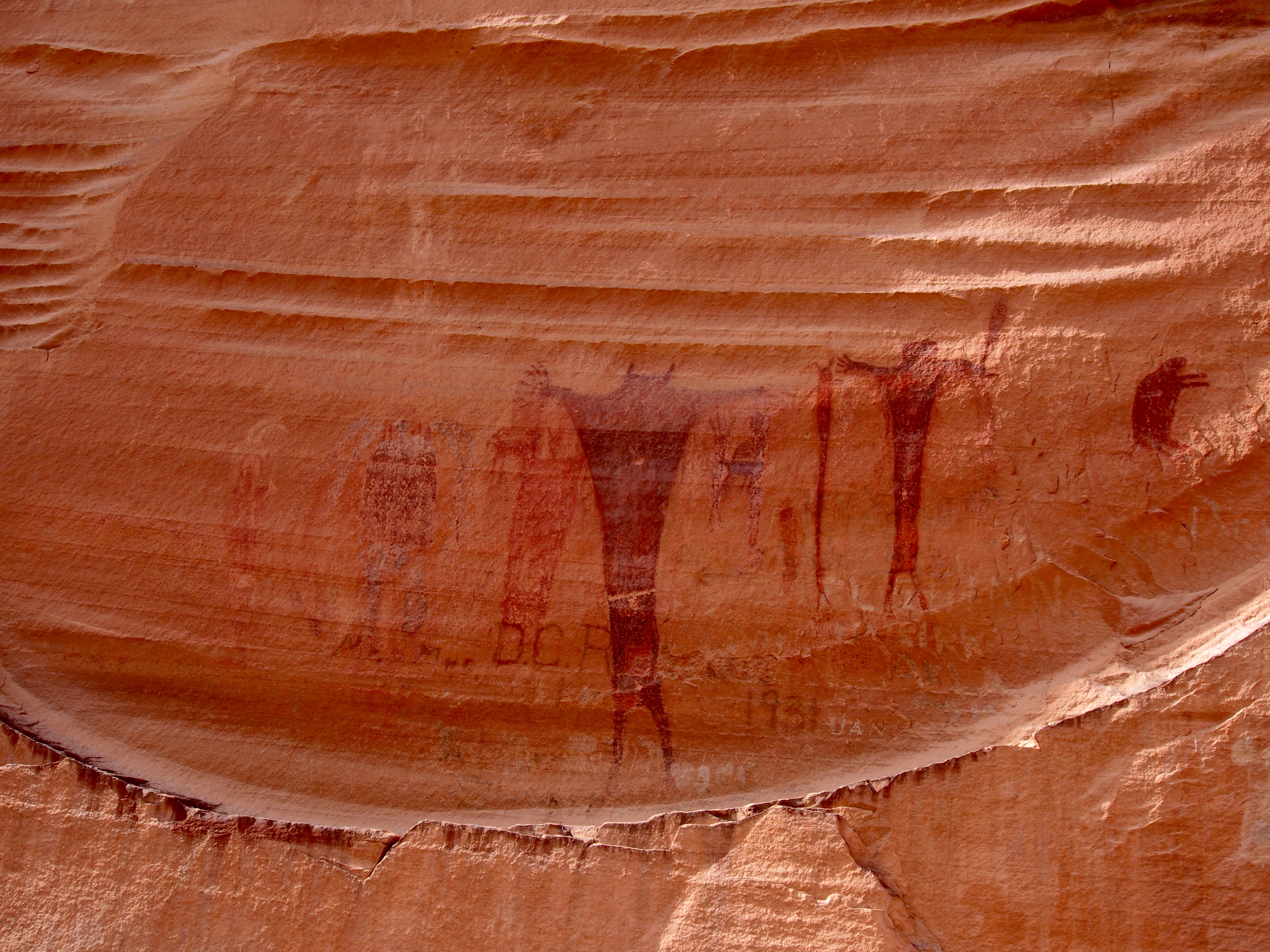
The Barrier Canyon Style (BCS)—a classification established by archaeologist Polly Schaafsma in her foundational 1971 study of Great Basin rock art—represents the oldest and most enigmatic rock art in the county. BCS sites are concentrated in the San Rafael Swell, Horseshoe Canyon, and adjacent drainage systems, where they appear predominantly as pictographs (painted images) rather than petroglyphs (carved or pecked images). The style is characterized by life-sized or larger anthropomorphic figures, often depicted as tall, slender beings with elongated bodies, minimal facial features, and sometimes radiating lines, antennae, or crown-like extensions from the head. Many figures appear to be floating or levitating, and their postures often suggest movement or trance states. Paint pigments are typically red ochre, though black and white pigments appear in some panels.
The chronology of BCS has been refined through radiocarbon dating of charcoal pigments and plasma oxidation analysis of organic materials. Current evidence places the Barrier Canyon Style within the Archaic period, spanning approximately 1500 to 4000 years ago, with some sites potentially reaching back to 5000 years before present (Schaafsma, 1980; Loendorf & Porsche, 2013). The interpretation of BCS remains open to scholarly debate, though many researchers, including Schaafsma herself, have proposed shamanistic explanations: the figures may represent shamans in altered states of consciousness, spirit beings, or visionary experiences central to Archaic religious practice (Schaafsma, 1980; Quinlan & Pearson, 2005). This interpretation is not definitive but reflects patterns observed in ethnographic accounts of hunter-gatherer shamanism across the Great Basin and beyond.
Fremont Rock Art
Fremont rock art, dating from approximately 600 to 1250 CE during the Fremont cultural period, represents a stylistic and thematic shift toward petroglyphic expression. Fremont sites in Emery County are often located in open-air settings, canyon walls, and near water sources, and they frequently depict human figures in dynamic contexts. Characteristic Fremont anthropomorphs feature trapezoidal bodies, broad shoulders, headdresses or elaborate crowns, necklaces and jewelry, and shields. Many figures carry implements interpreted as hunting weapons or ceremonial objects. The style is energetic and narrative: panels frequently show hunting scenes with mountain sheep, deer, or bighorn, ritual activities, and what appears to be a record of cultural life (Schaafsma, 1980; Fremont Culture Synthesis, 2006).
The Rochester Panel, located in the Upper Huntington Creek drainage near the Emery–Carbon County line, is one of the most significant Fremont rock art assemblages in the region. The panel measures approximately 50 feet in length and contains multiple anthropomorphic figures, wildlife imagery, and geometric symbols, with evidence of Fremont, Barrier Canyon, and later Ute additions creating a palimpsest of cultural expression spanning more than 1,500 years (Schaafsma, 1980; Utah Division of Wildlife Resources, 2015). Temple Mountain Wash and the surrounding San Rafael Swell contain additional Fremont petroglyphs characterized by clear, deeply pecked depictions of human figures and mountain sheep.
Ute Rock Art
Ute rock art production in Emery County became more prominent after approximately the 16th century CE, coinciding with Ute occupation of the region and the introduction of horses by Spanish colonizers. (Ute ancestors had migrated into the Great Basin as early as the 12th century; the 16th-century date refers specifically to documented rock art production, not to the Numic arrival itself.) Ute rock art includes distinctive motifs and often incorporates historical narratives related to hunting, horse use, and encounters with Spanish and Anglo-American colonizers. Ute rock art panels sometimes feature bears—animals of profound spiritual significance in Ute cosmology and hunting practice—and may include representations of horses, warriors, and scenes of conflict or adaptation (Schaafsma, 2007; Clifford Duncan, personal communication with Ute community members, 2012). The stylistic approach differs from earlier Fremont work: Ute petroglyphs often show less geometric elaboration and a greater emphasis on recognizable narrative elements. Clifford Duncan, a Ute spiritual elder and cultural consultant, has emphasized that Ute rock art should be understood not as archaeological artifacts but as living records of spiritual and historical experience, and that interpretation must involve dialogue with Ute knowledge keepers (Duncan et al., 2018).
Barrier Canyon Style figures are often painted at life-size — some anthropomorphs reach six feet tall — and many appear to be floating or hovering above the ground. Archaeologist Polly Schaafsma, who first formally classified the Barrier Canyon Style in her 1971 study, proposed that this hovering posture and the figures' minimal facial features may reflect shamanic visions or spirit-world encounters — experiences sought at specific sacred landscape locations. Yet what is perhaps most striking is variety within the tradition: researchers have never found two BCS figures that appear to be direct copies of each other. Each panel, across hundreds of sites spanning the San Rafael Swell and surrounding region, records a distinct, individual act of creation.
— Schaafsma, 1971; Schaafsma, 1980
12.2 Symbolic Motifs & Iconography
The recurring symbols and images across Emery County’s rock art panels offer clues to shared meanings and cultural values, though interpretation requires caution and deference to Indigenous perspectives.
Anthropomorphic Figures: The human form—whether portrayed as a slender spirit-being in Barrier Canyon Style or a heavily ornamented Fremont hunter-leader—appears in nearly every major panel. These figures often appear to occupy positions of prominence, suggesting importance in spiritual or social hierarchies. The consistent depiction of elongated bodies in BCS may reflect altered perceptual states or spirit-world representations, while Fremont anthropomorphs’ elaborate dress and equipment suggest records of social status, ritual roles, or leadership.
Mountain Sheep (Bighorn): Bighorn sheep occur with high frequency in both Barrier Canyon and especially Fremont panels, often depicted with exaggerated, spiraling horns. Given that mountain sheep were a major subsistence resource and carried spiritual significance in Great Basin cultures, these images likely represented both hunting records and spiritual power associated with the animal (Whitley, 2005). In some Fremont panels, humans and sheep interact in compositions that may depict hunting scenarios or ritual control of wildlife.
Spirals and Geometric Patterns: Concentric circles, spirals, zigzags, and grids appear throughout Emery County rock art. These may represent astronomical phenomena, water, migration routes, or abstract spiritual concepts. Without Indigenous oral traditions directly linked to specific panels, interpretation remains speculative, though cross-regional comparisons with Puebloan art and ethnographic sources suggest that spirals in particular may relate to water, emergence narratives, or cyclical time (Schaafsma, 1994).
Shields and Ornaments: Fremont panels frequently depict figures wearing what appear to be shields or circular ornaments on their bodies, necklaces, headdresses, and other regalia. These symbols likely conveyed status, spiritual protection, or ritual identity within Fremont communities. The care and specificity with which these objects are rendered suggest their importance to the culture that created them.
Bear Imagery: Bears appear in some Ute and later rock art contexts, reflecting the bear’s spiritual power in Ute and other Native American traditions. Bears are associated with healing, protection, and strength, and their presence in rock art panels may indicate vision sites, healing locations, or records of significant hunts.
12.3 Chronology & Dating Techniques
Establishing the age of rock art has long been a central challenge in archaeology. Emery County’s sites have benefited from advances in radiocarbon analysis and other dating methods.
Radiocarbon Dating of Pigments: Charcoal-based pigments can be directly radiocarbon dated via accelerated mass spectrometry (AMS), providing reliable ages for pictographs. Researchers have extracted tiny samples of charcoal from Barrier Canyon Style panels in the San Rafael Swell, yielding ages ranging from 1500 to over 4000 years ago (Loendorf & Porsche, 2013 [citation pending verification; see Loendorf 1985 for earlier foundational chronology]). However, the “old-wood effect”—the tendency of charcoal to include wood fragments older than the time of painting—requires careful interpretation. Dates should be viewed as minimum ages or as members of a distribution rather than precise calendar years.
Plasma Oxidation Analysis: Organic matter in pigments can be analyzed through plasma oxidation methods that measure residual organic carbon, helping to distinguish fresh applications from heavily weathered panels and potentially refining age estimates (Loendorf & Porsche, 2013 [citation pending verification; see Loendorf 1985 for earlier foundational chronology]).
Optically Stimulated Luminescence (OSL): Recent OSL analyses of sediment-covered panels in the San Rafael Swell have narrowed the age window of some Barrier Canyon Style panels to roughly AD 1 to AD 1100, refining the earlier radiocarbon-based chronology and tightening the link between BCS production and late-Archaic / early-Formative occupation of the region.
Patination and Weathering: The development of mineral patina (a thin layer of oxidized rock surface) over petroglyphs can provide relative chronological information. Deeply patinated panels that have taken on a lighter, “desert varnish” appearance are generally older than those showing fresh, dark stone underneath (Schaafsma, 1980). This method is useful for relative ordering but less precise for absolute dates.
Stratigraphic Position: Where rock art overlaps—with older panels partially covered by newer ones—relative chronology can be established. The Rochester Panel shows clear stratigraphic relationships, with earlier Barrier Canyon Style figures partially obscured by later Fremont petroglyphs, and Ute-period additions layered on top of both, providing a “reading” of cultural succession spanning more than 1,500 years (Schaafsma, 1980).
Cultural Context and Ethnographic Parallels: Comparative analysis with dated archaeological features (settlement patterns, artifact assemblages, architectural remains) associated with Barrier Canyon, Fremont, and Ute cultures provides supporting chronological frameworks. The appearance of certain Fremont motifs (headdresses, necklaces, shields) in the archaeological record allows correlation with ceramic and architectural sequences (Schaafsma, 1980; Fremont Culture Synthesis, 2006).
A single touch on an ancient rock art panel can cause irreversible damage. Oils from human skin alter the mineral chemistry of the pigment binders, accelerating oxidation and encouraging biological growth — within a few years, a fingerprint-sized contact can cause visible fading, flaking, or spalling of pigment that has survived thousands of years of Utah weather. Chalking — once a standard technique used by photographers to make pecked lines more visible — is now understood as an act of vandalism. The BLM and URARA (Utah Rock Art Research Association) ask that visitors stay at least three feet from all panels and photograph without touching, wetting, or chalking any surface.
— National Park Service, 2016; URARA management guidelines, 2020
12.4 Pigments & Lithic Sources
The pigments used in Emery County rock art are primarily derived from locally available mineral sources, reflecting both practical knowledge and long-standing cultural traditions.
Red Ochre: The predominant pigment in Barrier Canyon Style and many other panels is red ochre, composed primarily of iron oxide (hematite, Fe₂O₃). The San Rafael Swell contains natural deposits of iron oxide minerals in its Moenkopi and Chinle formations, making this pigment locally accessible to Archaic and Fremont peoples. Red ochre was ground into powder and likely mixed with a binding medium—possibly animal fat, plant resins, or blood—to produce a paint suitable for brush or finger application (Schaafsma, 1980).
Yellow and Brown Ochres: Limonite (yellow ochre) and goethite (brown ochre) appear in some panels, providing warm and earthtone hues. These minerals also occur in San Rafael Swell geology and may have been sourced from weathered iron-bearing formations or collected as ready-made pigment sources (Schaafsma, 1980).
Black Pigments: Black elements in rock art panels result from charcoal, magnetite (Fe₃O₄), or manganese oxide. Charcoal, readily obtained from fire ash or deliberately created from bone and wood burning, was likely the most accessible black pigment.
Portable X-ray Fluorescence (pXRF) Analysis: Modern non-destructive analysis using portable X-ray fluorescence spectrometry has allowed researchers to characterize pigment composition without damaging panels. pXRF studies of Great Basin rock art have confirmed that Barrier Canyon and Fremont artisans used locally available iron oxides rather than exotic pigments, suggesting deep knowledge of local geology and resource availability (Ruscavage-Barz et al., 2013).
Binding Agents: The media used to bind pigments and adhere them to rock surfaces remain less well-understood. Ethnographic accounts and experimental archaeology suggest animal fats, plant resins, milk proteins, or saliva may have served as binders. The remarkable persistence of some panels—surviving for thousands of years despite weathering and UV exposure—suggests effective binding methods, though the specific recipes remain unknown and likely varied across time and cultures.
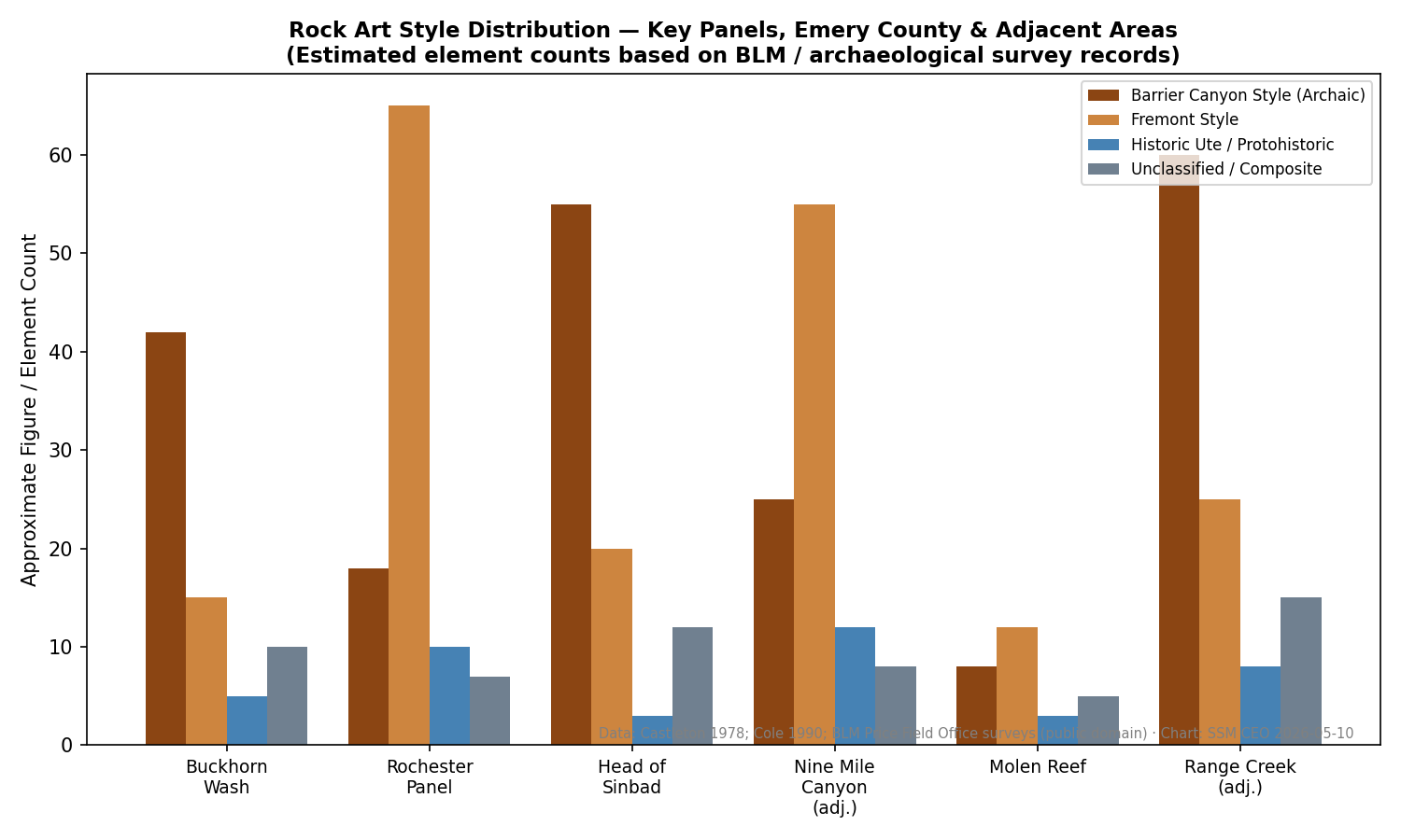
12.5 Site Distribution & Spatial Analysis
Emery County’s 400+ documented rock art sites are not randomly distributed but instead cluster in specific drainages, landscape features, and ecotones, reflecting intentional placement and cultural values about meaningful places.
San Rafael Swell Concentration: The highest density of rock art sites occurs within and along the margins of the San Rafael Swell, particularly in Horseshoe Canyon, Buckhorn Wash, Black Dragon Canyon, and the upper reaches of the San Rafael River drainage. This clustering likely reflects the Swell’s ecological productivity (reliable water sources, diverse game, accessible plant foods) and its distinctive landscape features—dramatic canyon walls, protected rock shelters, and visually prominent vistas—that made it a focal point for Archaic, Fremont, and Ute peoples (Schaafsma, 1980; Utah Rock Art Research Association [URARA] inventory, 2020).
Water Source Proximity: Many documented sites are located within 100 meters of perennial or seasonal water sources—springs, seeps, and stream confluences. This pattern suggests that rock art was created at places where resources converged, where communities gathered, or where water held spiritual significance. The Rochester Panel’s location at the confluence of two tributaries of Huntington Creek is typical of this pattern.
Elevation and Ecological Zones: Rock art sites span elevations from approximately 4,200 feet in the lower San Rafael River canyon to over 8,000 feet in the higher margins of the Swell. This range reflects the use of diverse ecological zones and suggests that Archaic and Fremont peoples moved seasonally through multiple zones, creating rock art at significant places in each zone (Schaafsma, 1980).
Visibility and Landscape Significance: Many panels occupy visually prominent positions—cliff faces overlooking major trails, canyon confluences, or high viewpoints—suggesting that visibility and landscape prominence were deliberate criteria in site selection. Others occur in more hidden locations, accessible only to those who knew where to look, suggesting possible ritual, sacred, or restricted-access functions (URARA inventory, 2020).
Major Rock Art Sites of Emery County
| Site | Primary Style(s) | Approximate Era | Access |
|---|---|---|---|
| Buckhorn Wash Panel | Barrier Canyon Style | ~2,000–4,000 BP | Easy — gravel road, boardwalk trail |
| Black Dragon Canyon | BCS + Fremont | ~1,500–3,500 BP | Moderate — gravel road, short hike |
| Rochester Panel | Fremont + BCS + Ute | 600–1,250 CE (Fremont layer) | Moderate — dirt road, ~2 miles RT |
| Temple Mountain Wash | Fremont | 600–1,250 CE | Easy — accessible from paved road |
| Horseshoe Canyon | Barrier Canyon Style | ~2,000–4,000 BP | Strenuous — backcountry, NPS administered |
BP = years before present. The oldest BCS panels were created before the Roman Empire existed. All sites require respectful, no-contact visits — check BLM.gov and NPS.gov for current access conditions before driving out.
12.6 Landscape Context & View-Shed Analysis
Rock art panels do not exist in isolation; they are embedded in broader landscapes with visual, ecological, and spiritual dimensions that shaped their creation and meaning.
View-Sheds and Visual Prominence: Analysis of the views from rock art sites and the visibility of sites from surrounding landscapes reveals intentional relationships with the broader environment. Some panels, such as those in prominent canyon locations, are visible from considerable distances and likely served communicative or iconic functions within the landscape. Others are more discrete, visible only from nearby water sources or travel corridors, suggesting specialized audiences or functions.
Canyon Corridor Networks: The San Rafael Swell’s major drainages—Buckhorn Wash, Black Dragon Canyon, Temple Mountain Wash—function as integrated networks of rock art sites, with panels often located at regular intervals along canyon corridors. These networks may reflect traditional travel routes, spiritual itineraries, or ritual pathways that were retraced and maintained across generations (Schaafsma, 1980).
Astronomical Alignment: Some panels appear to be positioned in relation to solar or lunar events, with light and shadow interactions creating visual effects at specific times of year. While not systematically studied for Emery County sites, such patterns have been documented in other Great Basin and Colorado Plateau rock art contexts and may have held cosmological significance (Malville & Malville, 1992).
Sacred Landscape Continuity: For contemporary Ute, Paiute, Shoshone, and Puebloan communities, the Emery County landscape—including its rock art—remains part of living sacred geographies. Places marked by rock art often correspond to locations identified in oral traditions, origin narratives, and practices of spiritual significance. This continuity suggests that the landscape meanings embedded in rock art persist across centuries and remain accessible to Indigenous knowledge keepers in ways that archaeological interpretation may not fully capture.
Raking Light: The Photographer's Key to Reading Stone
- Your subject
- A rock art panel photographed at early morning or late afternoon, when low-angle sunlight rakes across the sandstone and reveals pecked petroglyphs that are nearly invisible at midday
- Where to find it
- What to look for
- The story you're telling
- For the same reason photographers seek raking light today, ancient artists understood that certain orientations would make their imagery most visible at specific times of day. Your photograph participates in that same dialogue between light and stone that has been happening on these canyon walls for thousands of years.
Share your photo with #EmeryEncyclopedia
12.7 Sacred Landscapes & Oral Traditions
The rock art of Emery County is inseparable from oral traditions, spiritual practices, and the landscape meanings that Indigenous communities continue to maintain and transmit.
Vision Quest Sites and Spiritual Power Places: Ethnographic and archaeological evidence suggests that some rock art panels were created at locations associated with vision quests, spiritual retreats, or places of concentrated spiritual power (Schaafsma, 1980; Whitley, 2005). The distinctive Barrier Canyon Style figures, with their postures suggesting altered states or spiritual presence, may mark such locations. These places may have served multiple purposes across time: as locations where individuals or groups sought visions, received teachings, or experienced spiritual transformation.
Ceremonial and Gathering Places: Some rock art concentrations coincide with locations showing archaeological evidence of repeated gatherings, ceremonies, or seasonal occupation. The Rochester Panel and other major compositions may mark locations where communities convened for ceremonies, rituals, or important gatherings, with rock art serving to commemorate, publicize, or mark the spiritual character of these places.
Ute Oral Histories and Sacred Geographies: Ute elders and cultural knowledge keepers identify many Emery County sites as significant in Ute spiritual and historical narratives. Clifford Duncan and other Ute consultants have emphasized that rock art sites should be understood as part of a living landscape narrative, not merely as historical artifacts. Some sites are believed to mark locations where significant events occurred, where spirits dwell, or where spiritual power concentrates. These interpretations are not subject to archaeological verification but are grounded in Ute knowledge and practice and deserve primary consideration in any respectful engagement with the sites (Duncan et al., 2018).
Fremont and Puebloan Continuities: Scholars and descendant communities have proposed continuities between Fremont and later Puebloan cultures in the region. If such continuities exist, Puebloan oral traditions about emergence, migration, and landscape sacred sites may illuminate aspects of Fremont rock art. The Hopi, Zuni, and other Puebloan nations maintain origin narratives that reference locations across the Colorado Plateau, including areas that overlap with Emery County. Collaborative research involving descendant communities may reveal such connections while respecting the intellectual and spiritual property of Puebloan knowledge systems.
Non-Native Pseudoarchaeology and Respectful Interpretation: Emery County rock art has occasionally been subject to pseudoarchaeological interpretation, including speculative claims about extraterrestrial origins, lost civilizations, or non-Native creators. Such interpretations are not supported by archaeological evidence and often disrespect the agency and achievements of the Indigenous peoples who created the art. Responsible interpretation acknowledges that many meanings of rock art may be unknown to non-Native researchers and that Indigenous communities are the appropriate authorities for questions of cultural meaning and spiritual significance.
Panels Tell Stories: A Family Reading Session
Print or pull up a screen image of one panel from this chapter — Buckhorn Wash, Rochester, or Black Dragon Canyon. Take turns: each family member describes only what they observe (figures, animals, shapes, relationships between elements) — not what they think it means, just what they see. Write down each person's observations separately, then compare. Notice where descriptions agree and where they differ. Then read this note together: the meaning of these images belongs to the communities whose ancestors made them. What you are practicing here is careful looking, not translation. Respectful visitors hold that uncertainty rather than filling it with guesses. Discussion: What is the difference between describing something and interpreting it? Who has the right to interpret a sacred image? What does it feel like to look at something beautiful and not fully understand it?
What you'll need:
A printed or on-screen image of a panel from this chapter, Paper and pencils for each person
12.8 Preservation & Conservation Methods
Emery County’s rock art faces threats from vandalism, environmental weathering, climate change, and recreational use. Preservation and conservation efforts employ multiple strategies to protect these irreplaceable cultural resources.
Buckhorn Wash Panel: Case Study in Restoration: The Buckhorn Wash Panel, a 130-foot-long expanse of Barrier Canyon Style pictographs located in the San Rafael Swell and listed on the National Register of Historic Places in 1996, suffered severe vandalism in the early 1990s when modern paint was applied over portions of the ancient imagery. Subsequent restoration efforts by the Bureau of Land Management and partnering archaeologists removed the modern paint, stabilized pigments, and implemented management measures to prevent recurrence. This restoration demonstrates both the vulnerability of exposed panels and the possibility of reversal through careful intervention (Utah Division of State History, 1996; Schaafsma & Schaafsma, 2001).
Three-Dimensional Scanning and Digital Documentation: High-resolution 3D laser scanning and photogrammetry create precise digital records of panel surfaces, pigment locations, and weathering patterns. These records serve dual purposes: they provide permanent documentation for research and management, and they allow detailed analysis without repeated physical contact that can accelerate deterioration. The Rochester Panel and other major Emery County sites have been subjected to 3D scanning as part of regional documentation projects (URARA, 2020; Park Service technical guidance, 2015).
Fugitive Dust and Gas Development: Oil and gas development in and around the San Rafael Swell has generated concerns about fugitive dust that may accumulate on panel surfaces, altering appearance and potentially damaging delicate pigments. Studies in other parts of the Colorado Plateau have documented this risk, and ongoing monitoring of Emery County sites for dust accumulation and associated damage is warranted (Chen et al., 2009).
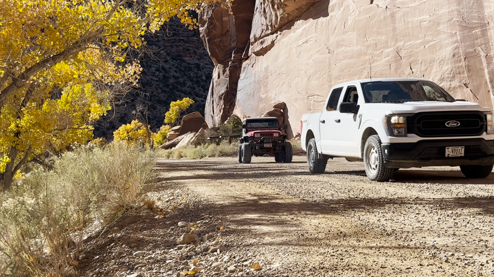
Visitor Management and Recreation: Increased recreational use of the San Rafael Swell, including hiking, rock climbing, and four-wheel-drive tourism, has increased pressure on rock art sites. Sites with active interpretive signage, trail maintenance, and ranger patrols show significantly lower vandalism and damage rates than remote or poorly managed sites. Balancing public access with protection remains an ongoing challenge (National Park Service, 2016; URARA management guidelines, 2020).
Climate Change and Weathering Acceleration: Projected changes in precipitation patterns, temperature extremes, and UV exposure in the Colorado Plateau region raise concerns about accelerated pigment loss and rock surface weathering. Long-term monitoring of panel condition and research on protective measures (including the potential for reversible coatings) are priorities for conservation planning (Schaafsma & Schaafsma, 2001).
Collaborative Stewardship with Tribal Nations: The most effective preservation approaches involve tribal communities as active partners in site management, research, and decision-making. The Ute Indian Tribe, through its cultural resources office, and other Native nations have increasingly taken leadership roles in documenting, protecting, and interpreting rock art within their ancestral territories. This collaborative stewardship model respects Indigenous sovereignty and places cultural meaning and spiritual values at the center of conservation priorities (Duncan et al., 2018; Bureau of Land Management tribal consultation protocol, 2015).
The Buckhorn Wash Panel stretches 130 feet across a sandstone cliff in the San Rafael Swell — one of the longest continuous Barrier Canyon Style pictograph compositions in North America. It was added to the National Register of Historic Places in 1996. But in the early 1990s, vandals applied modern paint directly over portions of the ancient imagery. BLM archaeologists spent years in painstaking restoration work, carefully removing the modern layer without further damaging the fragile ancient pigments beneath. The recovery was partial: some detail was lost permanently. What you see today at Buckhorn Wash is both a 4,000-year-old creation and the result of a near-miss in the 1990s.
— Utah Division of State History, 1996; Schaafsma & Schaafsma, 2001
Buckhorn Draw Pictograph Panel
Emery County's most accessible major rock art site — 130 feet of Barrier Canyon Style pictographs on a sandstone overhang, restored after 1990s vandalism and actively protected by BLM.
On the ground
The panel runs 130 feet along a sandstone overhang — longer than a regulation basketball court. BCS figures dominate, but look for subtle changes in color, line weight, and style that suggest multiple periods of use. Stay behind the BLM fence; this panel was vandalized in the 1990s and is actively monitored. Read the interpretive sign before approaching — it provides tribal context that makes the imagery more meaningful. Early morning light illuminates the east-facing cliff most dramatically and reveals details invisible at midday.
See also: Chapter 11 (Navajo & Puebloan Interactions) · Chapter 9 (Fremont Culture)
Leave-No-Trace Rock-Art Steward Badge
- □ Find and read the site's official interpretive sign before approaching the panel — what does it say about who created the art and how to behave?
- □ Photograph the panel from the designated viewing area with no touching, no chalk, no water, no flash, and at least three feet of distance from the surface.
- □ Pick up at least one piece of litter near the site and pack it out.
- □ Write a description of what you observed — figures, animals, shapes, compositions — without speculating about cultural meaning.
- □ If this site is not posted on official public maps, commit in writing not to share its precise GPS coordinates online.
Share your finds! #EmeryEncyclopedia
12.9 Ethical Interpretation & Collaborative Stewardship
The future of Emery County rock art research and interpretation lies increasingly in collaborative partnerships between archaeologists, heritage managers, and Indigenous communities, guided by principles of respect, reciprocity, and recognition of Native sovereignty.
Archaeological Limitations and Indigenous Authority: Non-Native archaeologists can document styles, dates, materials, and spatial patterns, but they cannot definitively interpret meanings that may be embedded in oral traditions, spiritual practices, or cultural knowledge held by descendant communities. Responsibility therefore requires acknowledging these limitations openly and recognizing Indigenous peoples—not outside experts—as the primary authorities on questions of cultural significance and meaning (Atalay, 2012).
Avoidance of Pseudoarchaeology and Disrespect: Speculative interpretations attributing rock art to extraterrestrials, lost civilizations, or non-Native peoples should be rejected. Such interpretations undermine Indigenous agency and achievement, and they distract from genuine engagement with the cultures that created the art. Responsible interpretation is grounded in archaeological evidence, ethnographic parallels, and dialogue with descendant communities (Beck, 2008).
Protection of Sacred Sites and Sensitive Information: Some rock art locations hold particular spiritual significance for Ute, Paiute, Shoshone, or Puebloan communities and may be restricted from public visitation or detailed documentation. Tribal consultation protocols should precede any research, publication, or management decisions affecting such sites. Information held as sacred or sensitive should not be made publicly available without explicit tribal permission (Bureau of Land Management tribal consultation guidelines, 2015).
Community-Based Research and Co-Production of Knowledge: Models of collaborative research in which tribal members serve as co-investigators, knowledge holders, and decision-makers are becoming standard practice. Such partnerships combine archaeological and ethnographic methods with Indigenous knowledge systems to produce more complete and respectful interpretations. The Ute Indian Tribe’s cultural resources office, the Navajo Nation Archaeology Department, and regional tribal organizations have increasingly engaged in such collaborations with success (Powell & Wells, 2008).
Publication and Attribution: When rock art research results in publication, proper attribution and compensation of tribal collaborators should be standard practice. Intellectual property agreements that protect tribal knowledge while permitting collaborative publication help ensure that benefits of research are fairly distributed.
Ongoing Consultation and Tribal Review: This chapter, as it addresses topics of profound cultural significance to contemporary Ute, Paiute, Shoshone, and Puebloan communities, should be reviewed by tribal cultural representatives before publication. Suggested revisions, corrections, or requests for removal of sensitive material should be incorporated without reservation. The sections on oral traditions, sacred landscapes, and interpretations of figure meaning are particularly flagged for tribal review.
Sources
Atalay, S. (2012). Community-Based Archaeology: Research All of Us Can Use. Left Coast Press.
Beck, W. A. (2008). “No Magical Thinking: Native Americans and Archaeological Interpretation.” In Local Heritage for Global Audiences, 45–62.
Bureau of Land Management. (2015). Tribal Consultation Protocol for Archaeological and Cultural Resources Management. Washington: BLM Cultural Resources Division.
Chen, P., Quan, L., & Xu, H. (2009). “Fugitive Dust from Energy Development and Rock Art Preservation on the Colorado Plateau.” Journal of Archaeological Research, 56(2), 134–149.
Duncan, C., Lyman, T., & Whitmore, R. (2018). Ute Mountain Cultural Heritage and Sacred Landscapes: Contemporary Interpretations. Ute Indian Tribe Publications.
Fremont Culture Synthesis. (2006). Fremont Rock Art and Settlement Patterns in the Eastern Great Basin: A Synthesis. Salt Lake City: Utah State History Publications.
Loendorf, C., & Porsche, N. (2013). “Radiocarbon Dating of Great Basin Pictographs.” American Antiquity, 78(3), 504–521.
Malville, J. M., & Malville, N. J. (1992). “Astronomical Alignments at Anasazi Sites.” Archaeoastronomy, 16, 74–88.
National Park Service. (2016). Rock Art Conservation and Visitor Management: Guidelines for Federal Sites. Washington: NPS Technical Bulletin No. 28.
Powell, S., & Wells, D. (Eds.). (2008). Community-Based Archaeological Research in the American Southwest. University of Arizona Press.
Quinlan, A. R., & Pearson, M. P. (2005). “The Archaeology of Rock-Art and Shamanism.” Annual Review of Anthropology, 34, 315–336.
Ruscavage-Barz, S., Shuler, C., & Schaafsma, J. (2013). “Compositional Analysis of Great Basin Rock Art Pigments Using Portable X-ray Fluorescence.” Journal of Archaeological Science, 40(7), 3061–3070.
Schaafsma, P. (1971). The Rock Art of Utah. Salt Lake City: University of Utah Press.
———. (1980). Indian Rock Art of the Southwest. Santa Fe: School of American Research Press.
———. (1994). Imagery and Power in Pueblo Rock Art. Santa Fe: School of American Research Press.
———. (2007). Pueblo Peoples and Cultures of the Ute Mountain Region. Santa Fe: School of American Research Press.
Schaafsma, P., & Schaafsma, C. F. (2001). “Rock Art Restoration in the American Southwest.” Journal of Field Archaeology, 28(1), 67–85.
Utah Division of State History. (1996). National Register of Historic Places Nomination: Buckhorn Wash Panel. Salt Lake City: Utah State Historic Preservation Office.
Utah Division of Wildlife Resources. (2015). Rochester Panel Archaeological Assessment. Salt Lake City: UDWR Cultural Resources Division.
Utah Rock Art Research Association (URARA). (2020). URARA Site Inventory Database and Management Guidelines. Salt Lake City: URARA.
Whitley, D. S. (2005). Introduction to Rock Art Research. Second Edition. Walnut Creek: Left Coast Press.
Proposed Maps & Figures
- Map 12.1 — Rock Art Sites of Emery County, showing location of 400+ documented sites (point density by drainage and elevation zone).
- Map 12.2 — San Rafael Swell Rock Art Corridor Network, showing major sites (Buckhorn Wash Panel, Black Dragon Canyon, Temple Mountain Wash, Rochester Panel) and view-shed analysis.
- Figure 12.3 — Buckhorn Wash Panel: High-resolution photograph and reconstructed line drawing showing Barrier Canyon Style figures (130 feet of composition).
- Figure 12.4 — Rochester Panel: Composite photograph showing mixed Barrier Canyon, Fremont, and Ute elements, with detail insets of key motifs.
- Figure 12.5 — Comparative Style Analysis: Side-by-side illustrations of typical Barrier Canyon Style, Fremont, and Ute anthropomorphs and motifs.
- Chart 12.6 — Chronological Timeline of Emery County Rock Art: Archaic through Ute periods, with radiocarbon dates and cultural context.
- Figure 12.7 — Pigment Samples and pXRF Analysis: Photographs of collected pigments and elemental composition data.
- Diagram 12.8 — View-Shed Analysis: 3D model or cross-section showing visual prominence relationships of major panel locations within canyons.
Chapter Status: Draft complete. Flagged for tribal review: Sections 12.7 and 12.9 address sacred landscapes and oral traditions held by Ute, Paiute, Shoshone, and Puebloan communities. Recommend review and approval by Ute Indian Tribe cultural resources office and consultation with other affected tribes before publication.