Part 1 · Foundations
Fauna
Wildlife across the elevation gradient: mammals, birds, reptiles, fish, and invertebrates of Emery County's diverse habitats.
Ch06 — Fauna
The same elevation gradient that stacks Emery County’s climates and vegetation zones into compressed bands (see Chapters 4 and 5) produces a corresponding layering of animal life. A pronghorn grazing sagebrush flats at 5,800 feet and an elk browsing aspen meadows at 9,500 feet are separated by less than twenty miles of horizontal distance but occupy different ecological worlds. Between them — and extending downward into the desert canyons of the San Rafael Swell — lives an animal community whose diversity would surprise anyone who thinks of east-central Utah as empty country. Emery County supports desert bighorn sheep, mountain lions, four federally endangered fish species, one of Utah’s largest wild horse herds, nesting peregrine falcons, and a cast of reptiles, amphibians, and invertebrates adapted to conditions ranging from Sonoran-grade aridity to subalpine snowfields. Understanding this fauna is essential to understanding the county: its wildlife shaped how settlers chose homesites, how ranchers manage range, how the Bureau of Land Management administers a quarter-million acres of public land, and how a growing recreation economy draws visitors into canyon country.
6.1 Mammalian Communities & Habitat Niches
Emery County’s mammals sort themselves along the elevation gradient with remarkable fidelity. The desert lowlands below 5,500 feet — the Green River corridor, the San Rafael Swell, and the Mancos Shale badlands — support a community of heat-adapted species: desert cottontail, black-tailed jackrabbit, kit fox, kangaroo rat, and white-tailed antelope squirrel. These animals are primarily nocturnal or crepuscular, avoiding the brutal midday heat that pushes summer temperatures above 100°F on exposed rock surfaces. Coyotes are ubiquitous, ranging from the river bottoms to the plateau summit and thriving in every habitat the county offers.
The mid-elevation sagebrush and pinyon-juniper zone (5,500 to 7,500 feet) supports the densest mammalian community. Mule deer winter here in large numbers, descending from the Wasatch Plateau when snow closes the high country. Pronghorn graze the sagebrush flats of Castle Valley and the northern San Rafael foothills — their keen eyesight and speed evolved for the open terrain that characterizes this zone. Bobcats, gray foxes, and badgers work the edges between sagebrush and juniper woodland, while rock squirrels and bushy-tailed woodrats occupy the cliff margins.
Above 7,500 feet, the montane and subalpine forests of the Wasatch Plateau support Rocky Mountain elk, which were reintroduced to the region and now maintain herds large enough to generate significant competition with mule deer for winter browse. Over 500 elk have been GPS-collared on the Wasatch unit by the Utah Division of Wildlife Resources (UDWR) to study movement patterns, seasonal migration timing, and habitat use. The plateau’s aspen groves, spruce-fir forests, and alpine meadows also harbor black bear, moose (in small numbers at the northern edge of their range), yellow-bellied marmots, and pine marten.
Mountain lions — the county’s apex predator — range across all elevation zones, following the deer and elk herds that constitute their primary prey. Lion sign has been documented in the San Rafael Swell canyons, along the Wasatch Plateau escarpment, and in the riparian corridors that connect the two. Their presence is a marker of ecological health: a landscape that supports mountain lions has sufficient prey base and habitat connectivity to function as a complete system (UDWR; Wild Aware Utah).
A pronghorn grazing sagebrush at 5,800 feet and an elk browsing aspen at 9,500 feet in Emery County are separated by less than twenty miles of horizontal distance — but they inhabit completely different ecological worlds. The pronghorn evolved for flat, open terrain where speed is survival; the elk is built for dense forest and deep snow. Drive the elevation gradient in either direction and you cross this boundary in under an hour. It is one of the most compressed ecological transitions in the American West.
6.2 Avian Diversity
Emery County sits at the intersection of the Great Basin and Colorado Plateau avifaunal provinces, a geographic position that enriches its bird list well beyond what the sparse human population might suggest. The county’s habitats — from desert washes to alpine tundra, with reservoirs, riparian corridors, and cliff faces in between — provide niches for resident species, breeding migrants, passage migrants, and winter visitors.
The sagebrush steppe supports greater sage-grouse, a species of significant conservation concern that depends on large, intact sagebrush landscapes for lekking, nesting, and brood-rearing. Sage-grouse populations across the Intermountain West have declined as sagebrush habitat has been fragmented by development, energy extraction, and invasive grasses. In Emery County, remaining sage-grouse habitat in Castle Valley and the northern county faces ongoing pressure from grazing, road construction, and potential energy development. The species is listed as a Species of Greatest Conservation Need (SGCN) under the Utah Wildlife Action Plan.
Pinyon-juniper woodlands — the county’s most extensive vegetation type — support a characteristic bird community that includes the pinyon jay, juniper titmouse, black-throated gray warbler, and gray flycatcher. Pinyon jays are colonial nesters whose populations track pinyon pine mast production; they function as seed dispersers essential to woodland regeneration (see Chapter 5).
The county’s reservoirs — Huntington North, Millsite, and Joe’s Valley — serve as staging and stopover sites for migratory waterfowl, including Canada geese, various duck species, and occasional shorebirds. During spring and fall migration, these small water bodies draw species that would otherwise bypass the arid interior.
Canyon wrens, white-throated swifts, and violet-green swallows are the signature species of the county’s sandstone canyon habitat. Their calls echo off the walls of the San Rafael Swell’s slot canyons and alcoves, providing the acoustic backdrop that hikers associate with the Colorado Plateau.
6.3 Reptiles of the Desert & Canyonlands
The San Rafael Swell and the lower desert country are reptile territory. The warm, rocky landscape provides the thermal environment that cold-blooded animals require, and the abundance of crevices, ledges, and sand offers shelter from predators and temperature extremes.
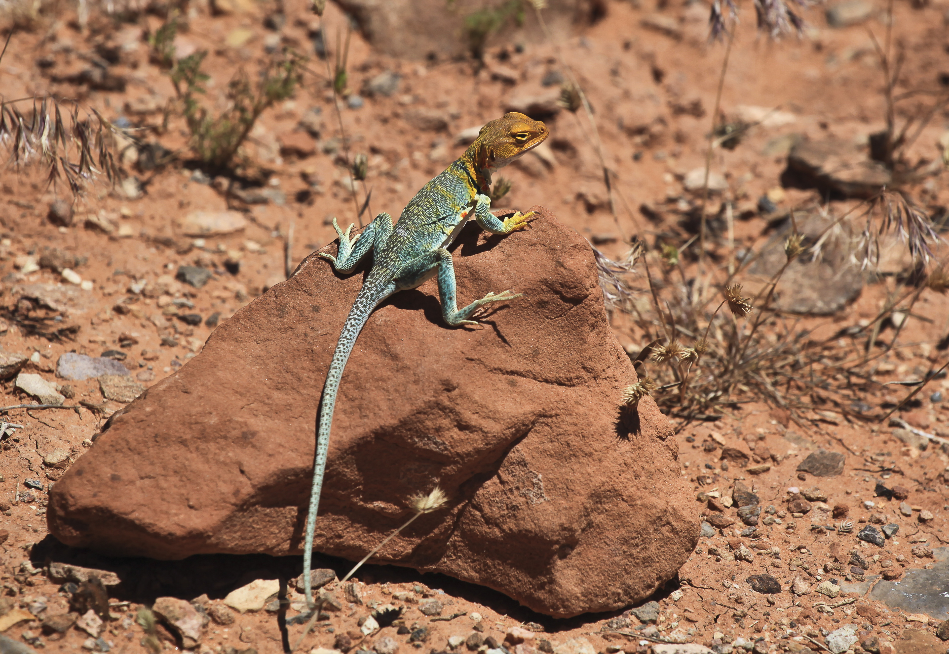
Lizards are the most visible reptiles, active on rock surfaces during morning and late afternoon when temperatures are favorable. Citizen-science observations through iNaturalist have documented desert collared lizards, long-nosed leopard lizards, plateau side-blotched lizards, northern tree lizards, plateau fence lizards, greater short-horned lizards, and western whiptails within the San Rafael Swell. The collared lizard — a vivid turquoise-and-orange species that runs on its hind legs when startled — is perhaps the most charismatic reptile a visitor is likely to encounter.
Among snakes, the midget faded rattlesnake deserves special attention. This pale-colored subspecies of the western rattlesnake has evolved a reduced pattern that matches the buff and cream tones of the Navajo Sandstone it inhabits. Found primarily in the canyon country of eastern Utah and western Colorado, it is small (rarely exceeding two feet), retiring, and medically significant only in the unlikely event of a bite to someone who handles it. Other snakes documented in the county include the Great Basin gopher snake (the most commonly encountered large snake), the desert striped whipsnake, and the wandering garter snake found near water sources.
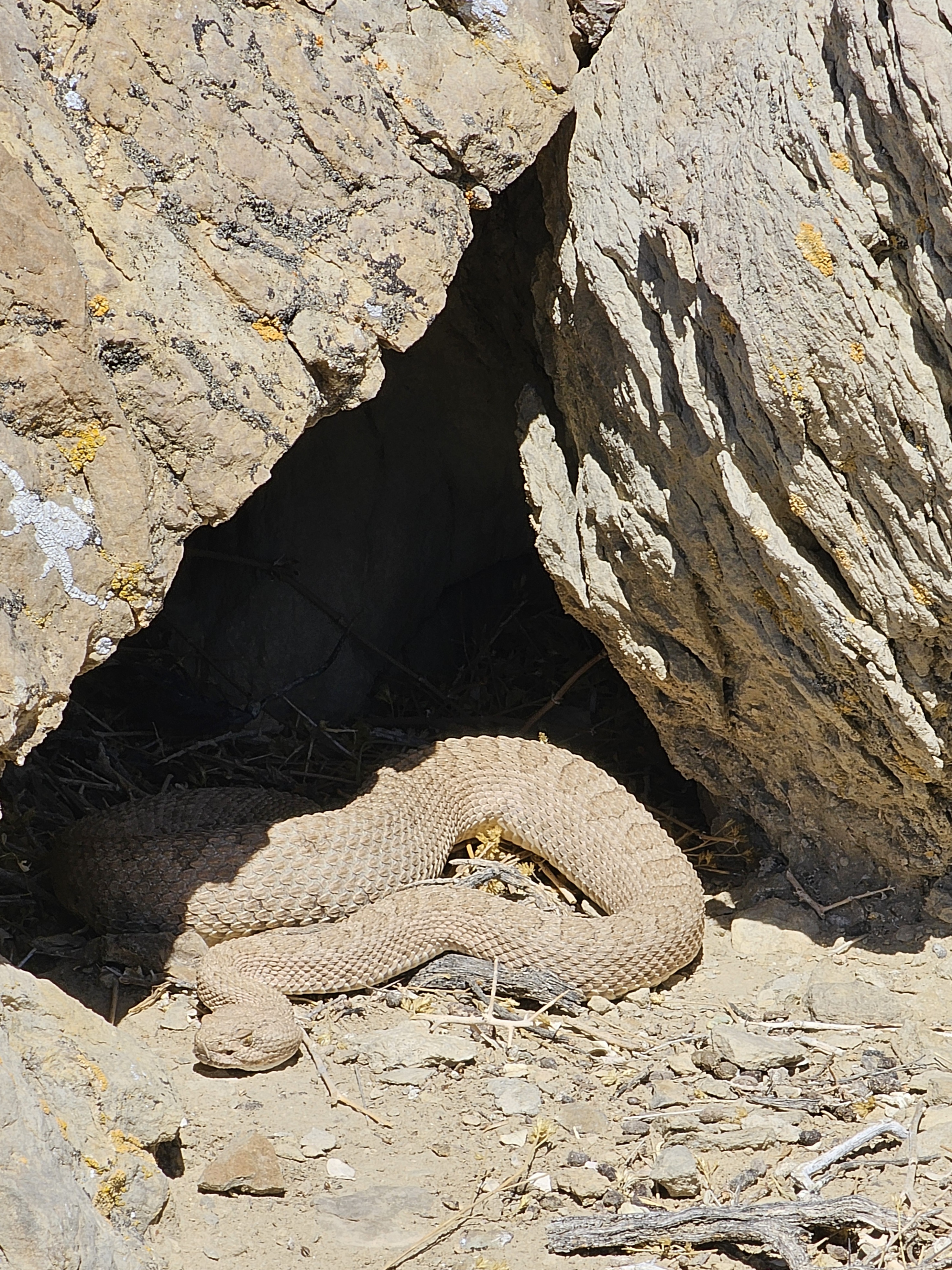
The midget faded rattlesnake has evolved a pale, almost translucent color pattern that perfectly matches the buff and cream tones of the Navajo Sandstone it inhabits — one of the most precise camouflage adaptations in any North American snake. Despite having potent venom, it is small (rarely more than two feet long), extremely shy, and poses almost no practical risk to hikers who do not attempt to handle it. If you see one basking on a canyon ledge in the San Rafael Swell, you are looking at an animal that has been adapting to this specific landscape for thousands of years. Admire it from a safe distance and move on.
6.4 Amphibians & Spring-Dependent Species
Amphibians occupy a precarious niche in Emery County’s arid landscape. Their dependence on water for reproduction confines them to the margins of springs, seeps, streams, and reservoirs — the same water features described in Chapter 3. Two species are confirmed in the region: the Great Basin spadefoot toad, which survives the dry months buried in soil and emerges after summer rains to breed explosively in temporary pools, and the Arizona tiger salamander, which inhabits permanent and semi-permanent water bodies at mid to high elevations.
The vulnerability of these species makes them sensitive indicators of hydrological change. Groundwater depletion, spring development for livestock watering, and climate-driven reductions in baseflow (see Chapter 4, Section 4.11) all threaten the water features that amphibians require. The northern leopard frog, once more widespread in Utah, is listed as a SGCN and may persist at scattered sites in the county, though confirmed recent records are lacking.
[needs additional sources] A systematic amphibian survey of Emery County’s springs and riparian habitats has not been located. Such a survey would be valuable for documenting current distributions and identifying conservation priorities.
6.5 Native Fishes
The Green River, which forms the eastern boundary of Emery County for approximately 70 miles, is one of the most important native fish habitats in the Colorado River basin — and one of the most imperiled. Four species listed under the federal Endangered Species Act swim these waters — three as endangered (Colorado pikeminnow, bonytail chub, and razorback sucker) and one as threatened (humpback chub, reclassified from endangered in 2021).
The Colorado pikeminnow was listed as endangered in 1967 — one of the first fish species to receive federal protection — and was subsequently covered under the Endangered Species Act of 1973. Historic accounts describe individuals growing to six feet in length and weighing over 80 pounds — the largest minnow species in North America. Dams, flow alteration, and competition from introduced species have reduced it to a fraction of its former range. The bonytail chub, listed in 1980, is the rarest of the four endangered natives and survives largely through hatchery supplementation. The humpback chub and razorback sucker occupy specialized niches in warm, turbulent river reaches and backwater habitats respectively.
Three additional native species — the roundtail chub, flannelmouth sucker, and bluehead sucker, collectively known as “the three species” — are classified as sensitive by the state of Utah and now occupy reduced ranges; the bluehead sucker, for example, inhabits roughly 50 percent of its historic Upper Colorado River basin range. A multi-agency conservation plan coordinates research, habitat protection, and population monitoring to prevent their listing under the ESA. Non-native predators and competitors, particularly northern pike and smallmouth bass, pose the most immediate threat. The UDWR has implemented catch-and-kill orders for these invasive species on the Green River to reduce predation pressure on natives (UDWR; Colorado River Recovery Programs).
The county’s reservoirs and higher-elevation streams support a different fishery — channel catfish and largemouth bass in the warm-water impoundments, and trout (both stocked and self-sustaining populations) in Huntington Creek and other cold-water tributaries of the Wasatch Plateau. These recreational fisheries are economically important but ecologically separate from the native fish conservation challenge in the Green River.
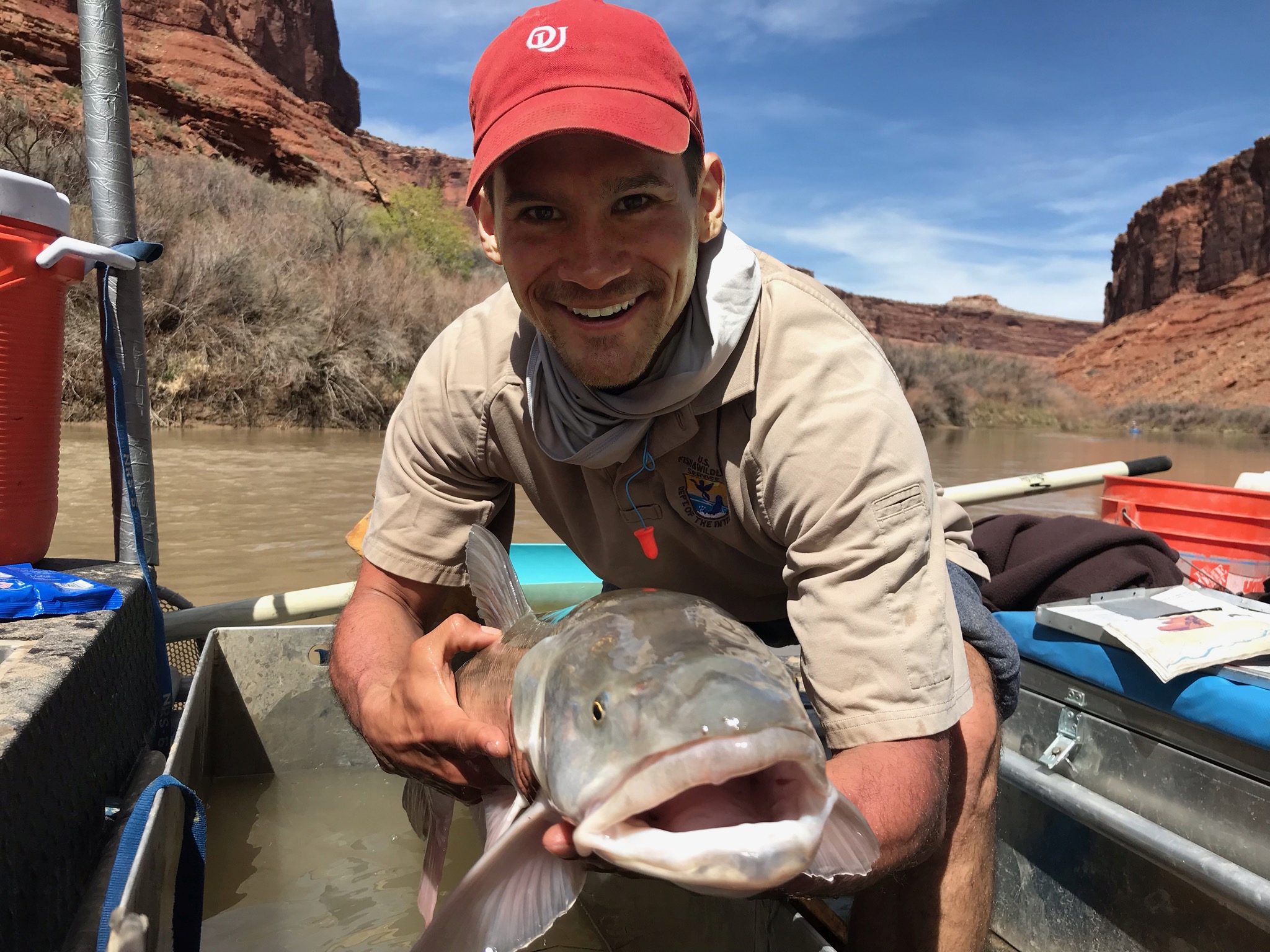
The Colorado pikeminnow — which swims the Green River along Emery County's eastern boundary — historically grew to six feet long and weighed over 80 pounds, making it the largest minnow species in North America. That is a fish the length of a standard kayak paddle, built like a torpedo, in a river shallow enough to wade across. It was one of the first species to receive federal endangered protection, listed in 1967 — before the Endangered Species Act existed in its current form. Today, adults rarely exceed four feet, and the species survives largely through hatchery supplementation and habitat restoration.
— Colorado River Recovery Programs; ESA listing records, 1967
6.6 Invertebrate Diversity
The invertebrate fauna of Emery County is the least documented component of its biodiversity — a gap that reflects both the difficulty of surveying small organisms across a vast landscape and the historical bias of wildlife management toward vertebrates. What is known suggests a community typical of the Colorado Plateau, with adaptations to aridity, extreme temperature swings, and sandy or rocky substrates.
Desert invertebrates include several scorpion species, tarantulas (likely the desert blonde tarantula, Aphonopelma iodius), darkling beetles (family Tenebrionidae, whose waxy cuticle reduces water loss), and a variety of ant species that play crucial roles in soil turnover and seed dispersal. The western bumblebee (Bombus occidentalis) is listed as a SGCN statewide and may occur in the county’s montane meadows, though confirmed records are lacking.
The springs and seeps described in Chapter 3 are likely to harbor the most ecologically significant invertebrate communities. Spring-dwelling mollusks — snails and springsnails adapted to specific water chemistry and temperature conditions — are among the most narrowly endemic organisms in the Intermountain West. Twenty-seven mollusk species are listed as SGCN statewide. Without targeted surveys, the county’s contribution to this diversity remains unknown.
[needs additional sources] No Emery County-specific entomological or malacological surveys have been located. University collections at BYU and USU may contain specimen records that would inform this section.
6.7 Raptor Migration & Nesting Cliffs
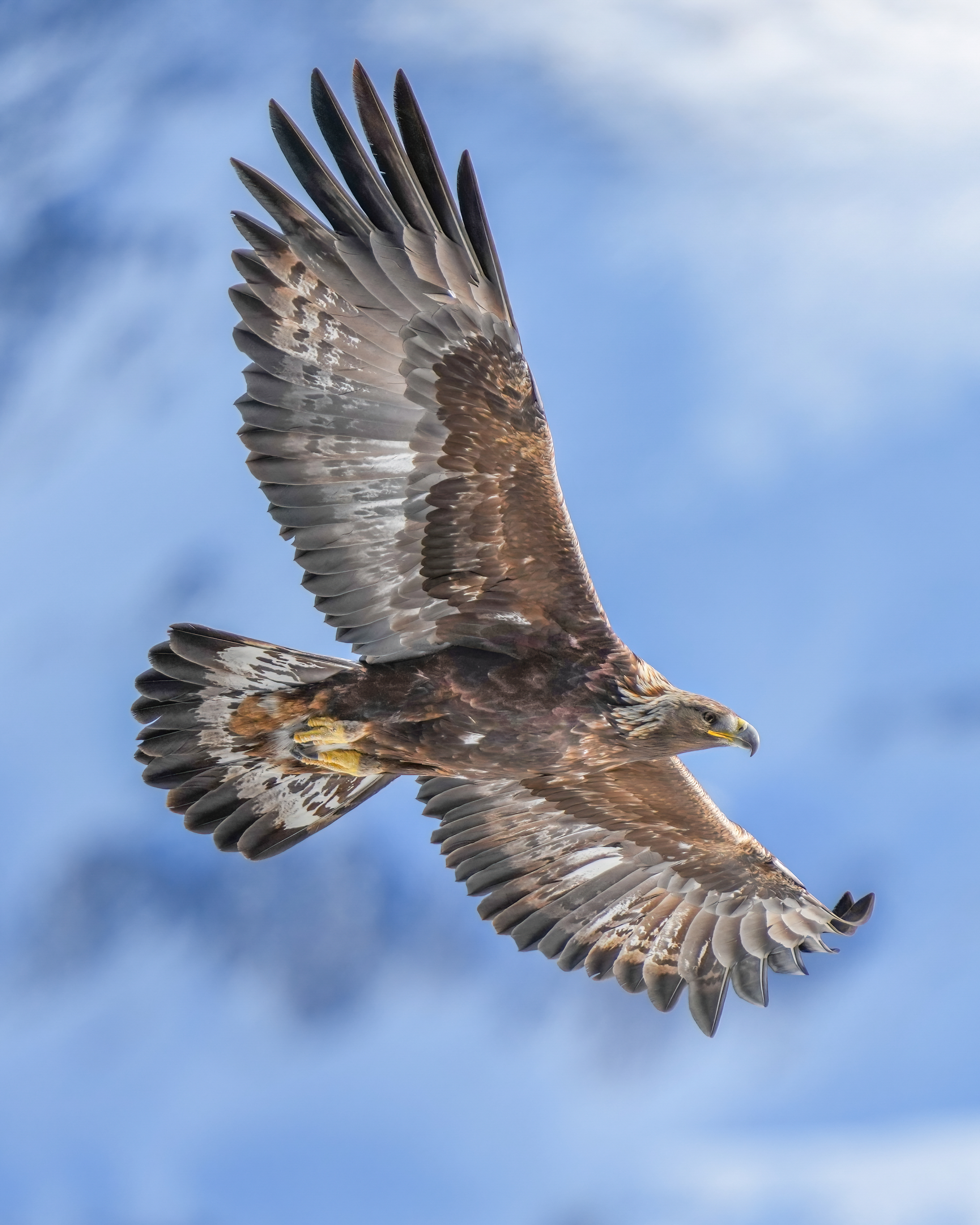
The cliff faces, mesas, and canyon rims of Emery County provide nesting habitat for an impressive assemblage of raptors. Golden eagles nest on high cliff ledges throughout the San Rafael Swell and along the Book Cliffs escarpment to the north. Bald eagles, once rare, are now regular winter visitors to the county’s reservoirs and the Green River corridor, where they feed on fish and waterfowl. Peregrine falcons — recovered from near-extinction after the DDT era — have reestablished nesting territories on canyon walls in the Swell, where the vertical sandstone provides the ledges and overhangs they require.
Red-tailed hawks are the most commonly seen raptor, perching on fence posts and power poles along Highway 10 through Castle Valley. Cooper’s hawks and sharp-shinned hawks work the riparian corridors and woodland edges. Northern harriers quarter the open sagebrush flats. American kestrels — the smallest falcon — are abundant in agricultural areas where they hunt grasshoppers and small rodents from perches on irrigation structures and hay bales.
The county’s position along the Intermountain flyway means that during spring and fall migration, additional raptor species pass through, including Swainson’s hawks, ferruginous hawks, and rough-legged hawks. The open terrain and reliable thermal updrafts along the San Rafael Reef make the area a natural concentration point for migrating raptors.
6.8 Big Game Herds
Big game hunting has been part of Emery County’s economy and culture since the first settlers arrived, and the management of deer, elk, pronghorn, and bighorn herds remains one of the most consequential wildlife issues in the county today.
Mule deer are managed under UDWR’s herd unit system. The county’s deer populations follow the classic Intermountain pattern: summer range on the Wasatch Plateau above 8,000 feet, autumn migration through the transitional pinyon-juniper zone, and winter concentration on the sagebrush and desert-shrub ranges of Castle Valley and the San Rafael foothills. The quality and carrying capacity of winter range is the limiting factor for deer populations — a constraint that has become more acute as elk herds have expanded into the same habitats.
Rocky Mountain elk on the Wasatch Plateau present both an opportunity and a management challenge. Elk are popular with hunters and generate significant economic activity through permit sales, outfitter services, and associated tourism. But on shared winter ranges, elk consume browse that mule deer depend on, and in heavy snow years, competition can contribute to elevated deer mortality. UDWR’s GPS-collaring program — with over 500 elk tracked — aims to quantify these interactions and inform management decisions about herd size objectives and hunt structures (UDWR Elk Statewide Management Plan).
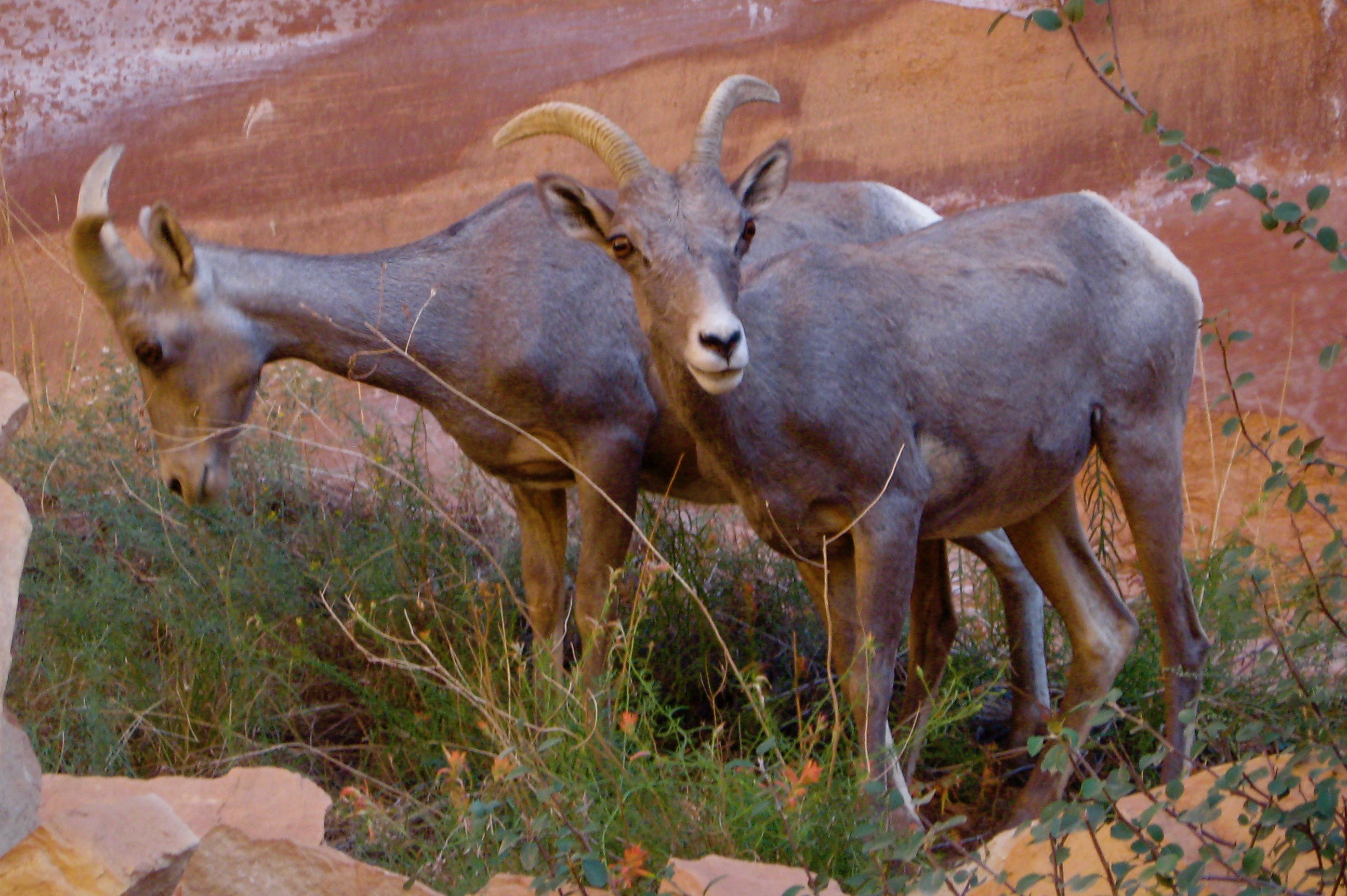
Desert bighorn sheep in the San Rafael Swell represent one of Utah’s most significant wildlife populations. The Swell’s canyon country provides the cliffs, escape terrain, and visual openness that bighorn require, and the herd is managed as a distinct population unit under the Utah Bighorn Sheep Statewide Management Plan. Bighorn are vulnerable to disease transmission from domestic sheep — a concern that affects grazing allotment decisions on adjacent BLM lands — and to habitat fragmentation from roads and recreation infrastructure.
Pronghorn, though less numerous than deer or elk, occupy an important ecological niche in the county’s sagebrush ecosystem. Their population tracks sagebrush habitat condition: where sagebrush is healthy and connected, pronghorn persist; where it has been converted, fragmented, or degraded, they decline.
6.9 Sensitive & Threatened Species
Emery County’s wildlife includes species at every level of conservation concern, from globally endangered to locally rare but nationally secure. The federal Endangered Species Act protects the four Green River fish species described in Section 6.5. The state of Utah’s Wildlife Action Plan (third edition, approved January 2026) identifies Species of Greatest Conservation Need across all taxonomic groups.
Among mammals, the Townsend’s big-eared bat is a SGCN species likely present in Emery County’s abandoned mine workings and canyon alcoves. These bats are sensitive to roost disturbance — a single visit to a hibernaculum during winter can cause mass arousal and fatal energy depletion. Mine closures by the BLM and Forest Service must balance safety concerns with bat habitat preservation, typically through the installation of bat-compatible gates that exclude humans but allow bats to pass freely.
Greater sage-grouse, discussed in Section 6.2, is the most politically prominent SGCN species in the county. Its conservation intersects with energy development, livestock grazing, and land-use planning across millions of acres of federal land in the western United States.
The Utah Wildlife Action Plan (3rd ed., 2026) identifies 256 Species of Greatest Conservation Need statewide — nearly double the 141 species in the 2015 plan — including 28 birds, 27 mammals, 3 reptiles, 1 amphibian, 105 insects, 17 mollusks, and 111 plants. The fraction of these present in Emery County is unknown without targeted surveys, but the county’s diversity of habitats — from alpine to desert, with springs, cliffs, and riparian corridors — suggests that a substantial number occur here.
6.10 Nocturnal Ecology
When the sun sets in Emery County, a second shift of wildlife takes over. The county’s exceptional dark skies (see Chapter 7) are not merely an astronomical asset — they reflect the absence of artificial light that is a prerequisite for the nocturnal ecological community.
Owls are the nocturnal counterpart to the daytime raptors described in Section 6.7. Great horned owls are the apex nocturnal predator, hunting rabbits and rodents across all habitat zones. Western screech-owls inhabit riparian woodlands and canyon alcoves. Long-eared owls roost in dense juniper groves. Burrowing owls — a SGCN species — may occupy abandoned prairie dog burrows in the sagebrush country, though their status in Emery County is uncertain.
Common nighthawks and common poorwills — goatsuckers adapted to catching flying insects in flight — are summer residents of the desert and sagebrush zones. Their distinctive calls at dusk are a familiar sound in Castle Valley and the San Rafael during warm months.
Among mammals, the nocturnal community includes multiple bat species (insectivorous bats are critical for pest control in agricultural areas), ringtails (a relative of the raccoon found in rocky canyon habitat), kangaroo rats (whose bipedal locomotion and enlarged auditory bullae are adaptations to predator evasion in open desert), and a suite of small rodents — deer mice, woodrats, and pocket mice — that form the prey base for owls, snakes, and kit foxes.
The increasing recognition of light pollution as an ecological stressor has implications for Emery County. While the county’s current light levels are minimal, any future development — energy installations, highway lighting, or commercial growth — should consider impacts on nocturnal wildlife as well as dark-sky quality.
6.11 Seasonal Phenology & Migrations
The animal life of Emery County runs on a seasonal clock set by the elevation gradient, the bimodal precipitation pattern described in Chapter 4, and the photoperiod changes that trigger migration and breeding across the Northern Hemisphere.
Spring (March–May) brings the most dramatic transitions. Mule deer and elk begin their upward migration from winter range to summer pastures on the Wasatch Plateau, following the retreating snowline and the flush of new green growth. Migratory songbirds arrive from the south: warblers, flycatchers, and swallows returning to breeding territories. Amphibians emerge from dormancy — spadefoot toads may breed within days of the first substantial rain. Raptors arrive on nesting territories and begin courtship displays.
Summer (June–August) is the breeding season for most resident species. Desert reptiles are most active during the warm months, and the monsoon rains of July and August trigger a pulse of invertebrate activity that supports insectivorous birds and bats. Fawn drop for mule deer peaks in June on the high summer ranges. Bighorn lambing occurs on cliff ledges in the Swell, where the terrain provides security from predators.
Autumn (September–November) reverses the spring migration. Elk bugling echoes through the Wasatch Plateau aspen groves in September and October — one of the county’s most evocative natural sounds. Deer begin moving downslope as snow accumulates. Migratory raptors pass through on their way south, and waterfowl stage briefly on the reservoirs.
Winter (December–February) concentrates wildlife on the lower elevations. Mule deer herds gather on winter ranges in Castle Valley, where their survival depends on the condition of sagebrush and bitterbrush browse. Bald eagles arrive to winter along the Green River. Small mammals — voles, mice, and shrews — remain active beneath the snow, connected by subnivean tunnel networks invisible from the surface. The Wasatch Plateau above 9,000 feet becomes largely depopulated of large mammals, though pine marten and snowshoe hare (if present at this latitude) may remain active in the deep-snow zone.
6.12 Wildlife Management & Citizen Science
Wildlife management in Emery County is a shared responsibility among federal, state, and local entities whose jurisdictions overlap across the county’s complex land-ownership mosaic. The Bureau of Land Management administers roughly 2.7 million acres of public land in the Price Field Office area (which includes Emery County), managing wildlife habitat alongside livestock grazing, energy development, recreation, and wild horse populations. The U.S. Forest Service manages the Wasatch Plateau lands within the Manti-La Sal National Forest, including critical elk and deer summer range. UDWR holds authority over wildlife populations themselves — setting harvest quotas, managing transplant programs, and conducting population surveys across all landownerships.
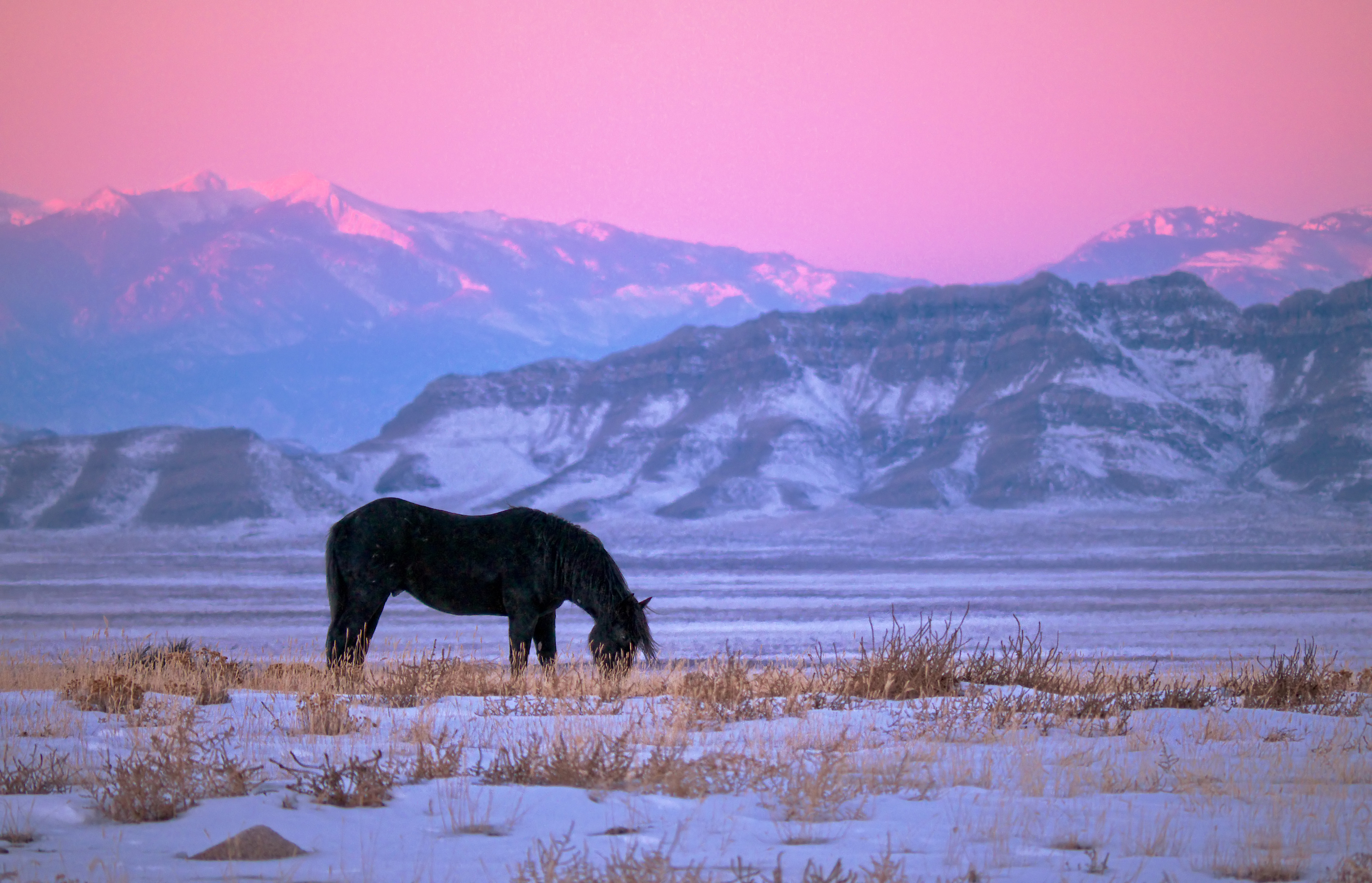
The most contentious wildlife management issue in the county is arguably the Muddy Creek wild horse herd. The BLM’s Muddy Creek Herd Management Area encompasses approximately 283,400 acres of public and state land south of the town of Emery, extending north and south of Interstate 70 across the heart of the San Rafael Swell. The Appropriate Management Level (AML) is 75 to 125 horses, but the population has chronically exceeded this target, reaching an estimated 400 or more animals. Drought conditions in 2018 and again in 2025 forced emergency gather operations when forage and water became insufficient to sustain the overpopulated herd — horses were found in deteriorating body condition, and one 2025 gather removed 153 animals. The management of wild horses pits advocates for free-roaming herds against concerns about rangeland degradation, competition with native wildlife (particularly desert bighorn and pronghorn), and water-source depletion. Fertility control treatments are applied after gathers to slow population growth, but the issue remains unresolved and politically charged (BLM Muddy Creek HMA).
Citizen science is an increasingly important tool for documenting Emery County’s wildlife. The iNaturalist platform hosts a San Rafael Swell and Desert checklist with observations dating from 2023 through the present, providing real-time species documentation that supplements formal agency surveys. The Christmas Bird Count and Breeding Bird Survey programs contribute long-term avian monitoring data. As smartphone-based observation tools become more widespread, citizen scientists — including hikers, hunters, and ranchers — have the potential to fill many of the data gaps identified in this chapter, particularly for invertebrates, amphibians, and nocturnal species that are poorly represented in traditional wildlife surveys.
The Muddy Creek Wild Horse Herd by the Numbers
| Metric | Figure |
|---|---|
| Herd Management Area size | 283,400 acres |
| Target population (Appropriate Management Level) | 75–125 horses |
| Estimated population (recent years) | 400+ horses |
| Animals removed — 2025 emergency gather | 153 horses |
The HMA covers the heart of the San Rafael Swell, where horses compete with desert bighorn, pronghorn, and native vegetation for water and forage in a landscape that receives only 6 to 8 inches of rain per year.
Sources
- Utah Division of Wildlife Resources, “Big Game Animals” and herd unit management plans (wildlife.utah.gov).
- Utah Division of Wildlife Resources, “Utah Bighorn Sheep Statewide Management Plan” (wildlife.utah.gov/pdf/bg/bighorn-plan.pdf).
- Utah Division of Wildlife Resources, “Utah Statewide Elk Management Plan” (wildlife.utah.gov/pdf/bg/elk_plan.pdf).
- Utah Division of Wildlife Resources, “Utah Mule Deer Statewide Management Plan, 2025–2030.”
- Utah Division of Wildlife Resources, “Utah’s Species of Greatest Conservation Need” (2025 list; wildlife.utah.gov/pdf/WAP/2025-08-sgcn-list.pdf).
- Utah Division of Wildlife Resources, “Utah Wildlife Action Plan” (3rd ed., approved January 2026; wildlife.utah.gov/wildlife-action-plan.html).
- Utah Division of Wildlife Resources, “The Three Species” (Wild Podcast, Ep. 70; wildlife.utah.gov/wild-podcast).
- Bureau of Land Management, “Muddy Creek Herd Management Area” (blm.gov).
- Bureau of Land Management, “2025 Muddy Creek Wild Horse Gather” (blm.gov).
- Bureau of Land Management, “San Rafael Reef WSA” (blm.gov).
- Colorado River Recovery Programs, “Threatened and Endangered Fish Species” (coloradoriverrecovery.org).
- iNaturalist, “San Rafael Swell and Desert Check List” (inaturalist.org/check_lists/64400).
- Wild Aware Utah, “Mule Deer” and “Birds of Prey” (wildawareutah.org).
- Pew Charitable Trusts, “Utah’s San Rafael Swell” (July 2015).
- USGS, “Maintaining Population Persistence in the Face of an Extremely Altered Hydrograph” (pubs.usgs.gov/publication/70003835).
- Visit Emery County, “The Swell” (visitemerycounty.com).
Proposed Maps & Figures
- Map: Wildlife Habitat Zones of Emery County — Elevation-based zones (desert, sagebrush-steppe, pinyon-juniper, montane forest, subalpine) with characteristic species labeled in each zone.
- Map: Muddy Creek Herd Management Area — HMA boundaries, I-70 corridor, town of Emery, and key water sources.
- Map: UDWR Big Game Management Units — Deer, elk, pronghorn, and bighorn units overlapping Emery County.
- Figure: Elevation–Species Distribution Diagram — Cross-section showing which key species occupy each elevation band, from Green River to the Wasatch Plateau summit.
- Table: ESA-Listed and SGCN Species in Emery County — Species name, status, habitat, primary threats.
Proposed Photographs
- Desert bighorn sheep on sandstone cliffs in the San Rafael Swell.
- Wild horses in the Muddy Creek HMA.
- Colorado pikeminnow (archival or UDWR photo).
- Midget faded rattlesnake on Navajo Sandstone.
- Golden eagle in flight over mesa country.
- Collared lizard on rock surface.
Wildlife Bingo on the Elevation Gradient
Before your trip, draw a 4x4 bingo grid and fill each square with an animal from Emery County: easy ones like mule deer, raven, lizard, and jackrabbit alongside harder ones like pronghorn, golden eagle, desert bighorn sheep, and collared lizard. As you drive from the Green River valley through Castle Valley and into the higher country, check off each animal you spot. First to get four in a row wins. Stop at overlooks and stay quiet for a few minutes — you spot more wildlife when the car noise fades. At the end of the day, compare what you saw at low elevation versus high: does it match the habitat zones in Section 6.1?
What you'll need:
Blank paper and pencil for bingo cards, Binoculars if available
Wildlife Sign Hunt
- □ A lizard basking on a rock — wait quietly near a sunny rock face in the morning or late afternoon.
- □ Animal tracks in mud, sand, or soft soil that you can identify to species. Look near water sources, stream banks, and dusty trail margins.
- □ A raptor nest on a cliff ledge — look for a large stick platform, whitewash staining on the rock below it, and possibly the adult bird perched nearby.
- □ Wild horses in or near the Muddy Creek HMA south of the town of Emery — look near water sources and stock ponds.
- □ Pronghorn in the sagebrush flats — their white rump patches flash in sunlight and give them away at long distances.
Share your finds! #EmeryEncyclopedia
The San Rafael Swell Wildlife Loop
Canyon lizards, bighorn sheep, wild horses, and peregrine falcons — a full-day wildlife excursion through Emery County's premier habitat.
On the ground
Morning: scan sagebrush flats near Temple Mountain for pronghorn in early light; check sandstone towers along the San Rafael Reef for raptor nests. Mid-morning: hike Crack Canyon or Little Wild Horse Canyon — watch for collared lizards on sunny rock faces and listen for canyon wrens echoing off the walls. Lunch at Goblin Valley: scan rimrock for desert bighorn using cliff edges as escape terrain. Afternoon: drive north through the Muddy Creek HMA — wild horses are most often seen near water sources. Dusk: return to the Swell and listen for great horned owls; watch for bats emerging from cliff crevices at last light.
See also: Chapter 5 (Flora Zones) · Chapter 7 (Night Skies & Astronomy)